You are here: Home > Network List > UW - Pacific Northwest Regional Seismic Network Stations List
> Station GBB GBB, Hanford, WA, USA > Earthquake Result Viewer
GBB GBB, Hanford, WA, USA - Earthquake Result Viewer
| Earthquake location: |
Southeast Of Loyalty Islands |
| Earthquake latitude/longitude: |
-22.9/172.0 |
| Earthquake time(UTC): |
2022/05/26 (146) 15:38:03 GMT |
| Earthquake Depth: |
10 km |
| Earthquake Magnitude: |
6.9 Mi |
| Earthquake Catalog/Contributor: |
NEIC PDE/at |
|
| Network: |
UW Pacific Northwest Regional Seismic Network |
| Station: |
GBB GBB, Hanford, WA, USA |
| Lat/Lon: |
46.61 N/119.63 W |
| Elevation: |
185 m |
|
| Distance: |
92.6 deg |
| Az: |
39.907 deg |
| Baz: |
239.104 deg |
| Ray Param: |
0.041424226 |
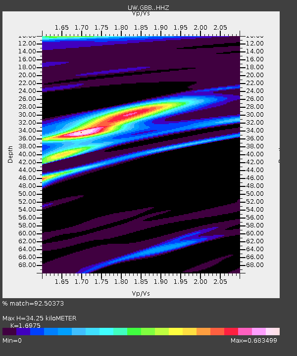
| Estimated Moho Depth: |
34.25 km |
| Estimated Crust Vp/Vs: |
1.70 |
| Assumed Crust Vp: |
6.419 km/s |
| Estimated Crust Vs: |
3.782 km/s |
| Estimated Crust Poisson's Ratio: |
0.23 |
|
| Radial Match: |
92.50373 % |
| Radial Bump: |
352 |
| Transverse Match: |
75.9657 % |
| Transverse Bump: |
400 |
| SOD ConfigId: |
27527651 |
| Insert Time: |
2022-06-09 16:06:14.600 +0000 |
| GWidth: |
2.5 |
| Max Bumps: |
400 |
| Tol: |
0.001 |
|

Signal To Noise
| Channel | StoN | STA | LTA |
| UW:GBB: :HHZ:20220526T15:50:43.179993Z | 29.992624 | 2.1680837E-6 | 7.2287236E-8 |
| UW:GBB: :HHN:20220526T15:50:43.179993Z | 4.982323 | 2.947847E-7 | 5.9166112E-8 |
| UW:GBB: :HHE:20220526T15:50:43.179993Z | 7.49217 | 3.9107633E-7 | 5.2198004E-8 |
| Arrivals |
| Ps | 3.8 SECOND |
| PpPs | 14 SECOND |
| PsPs/PpSs | 18 SECOND |


