You are here: Home > Network List > UW - Pacific Northwest Regional Seismic Network Stations List
> Station RPW2 RPW2, Rockport WA > Earthquake Result Viewer
RPW2 RPW2, Rockport WA - Earthquake Result Viewer
| Earthquake location: |
Southeast Of Loyalty Islands |
| Earthquake latitude/longitude: |
-22.9/172.0 |
| Earthquake time(UTC): |
2022/05/26 (146) 15:38:03 GMT |
| Earthquake Depth: |
10 km |
| Earthquake Magnitude: |
6.9 Mi |
| Earthquake Catalog/Contributor: |
NEIC PDE/at |
|
| Network: |
UW Pacific Northwest Regional Seismic Network |
| Station: |
RPW2 RPW2, Rockport WA |
| Lat/Lon: |
48.44 N/121.53 W |
| Elevation: |
694 m |
|
| Distance: |
92.5 deg |
| Az: |
37.667 deg |
| Baz: |
237.808 deg |
| Ray Param: |
0.041447982 |
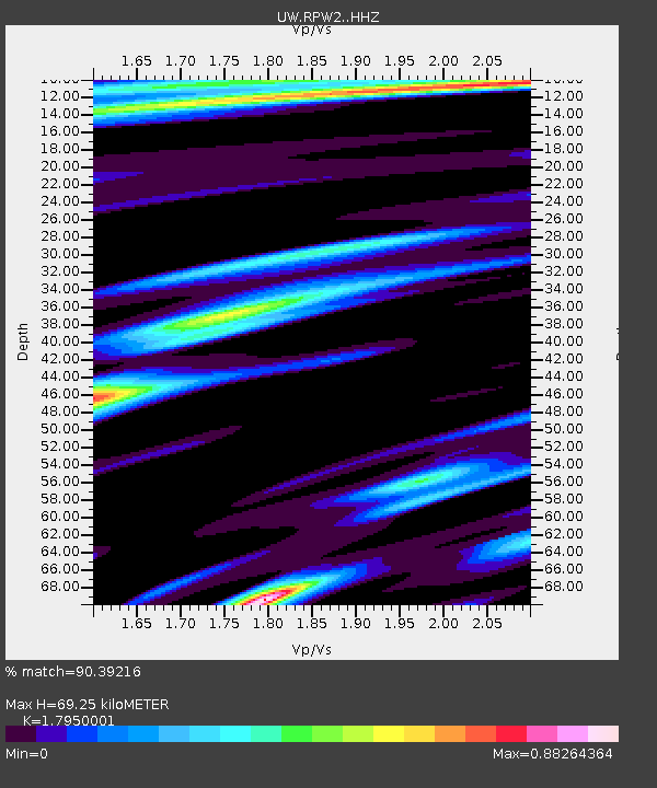
| Estimated Moho Depth: |
69.25 km |
| Estimated Crust Vp/Vs: |
1.80 |
| Assumed Crust Vp: |
6.566 km/s |
| Estimated Crust Vs: |
3.658 km/s |
| Estimated Crust Poisson's Ratio: |
0.27 |
|
| Radial Match: |
90.39216 % |
| Radial Bump: |
400 |
| Transverse Match: |
73.933685 % |
| Transverse Bump: |
400 |
| SOD ConfigId: |
27527651 |
| Insert Time: |
2022-06-09 16:07:22.695 +0000 |
| GWidth: |
2.5 |
| Max Bumps: |
400 |
| Tol: |
0.001 |
|

Signal To Noise
| Channel | StoN | STA | LTA |
| UW:RPW2: :HHZ:20220526T15:50:42.559998Z | 25.485485 | 1.6240168E-6 | 6.3723206E-8 |
| UW:RPW2: :HHN:20220526T15:50:42.559998Z | 6.036645 | 3.5261985E-7 | 5.841322E-8 |
| UW:RPW2: :HHE:20220526T15:50:42.559998Z | 13.333397 | 4.6403804E-7 | 3.4802685E-8 |
| Arrivals |
| Ps | 8.6 SECOND |
| PpPs | 29 SECOND |
| PsPs/PpSs | 37 SECOND |


