You are here: Home > Network List > NE - New England Seismic Network Stations List
> Station EMMW Machias, ME > Earthquake Result Viewer
EMMW Machias, ME - Earthquake Result Viewer
*The percent match for this event was below the threshold and hence no stack was calculated.
| Earthquake location: |
Kuril Islands |
| Earthquake latitude/longitude: |
48.3/154.2 |
| Earthquake time(UTC): |
2009/09/10 (253) 02:46:50 GMT |
| Earthquake Depth: |
36 km |
| Earthquake Magnitude: |
6.0 MB, 5.5 MS, 6.0 MW, 5.8 MW |
| Earthquake Catalog/Contributor: |
WHDF/NEIC |
|
| Network: |
NE New England Seismic Network |
| Station: |
EMMW Machias, ME |
| Lat/Lon: |
44.71 N/67.46 W |
| Elevation: |
34 m |
|
| Distance: |
80.4 deg |
| Az: |
28.723 deg |
| Baz: |
333.264 deg |
| Ray Param: |
$rayparam |
*The percent match for this event was below the threshold and hence was not used in the summary stack. |
|
| Radial Match: |
57.374027 % |
| Radial Bump: |
400 |
| Transverse Match: |
64.03234 % |
| Transverse Bump: |
400 |
| SOD ConfigId: |
2622 |
| Insert Time: |
2010-03-09 20:22:13.066 +0000 |
| GWidth: |
2.5 |
| Max Bumps: |
400 |
| Tol: |
0.001 |
|
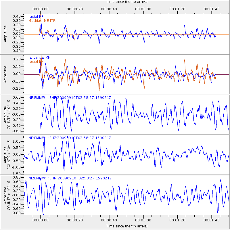
Signal To Noise
| Channel | StoN | STA | LTA |
| NE:EMMW: :BHZ:20090910T02:58:27.159021Z | 2.1945014 | 7.490367E-7 | 3.4132432E-7 |
| NE:EMMW: :BHN:20090910T02:58:27.159021Z | 1.8007737 | 5.077465E-7 | 2.8196018E-7 |
| NE:EMMW: :BHE:20090910T02:58:27.159021Z | 0.35938153 | 1.15696935E-7 | 3.2193344E-7 |
| Arrivals |
| Ps | |
| PpPs | |
| PsPs/PpSs | |


