You are here: Home > Network List > UW - Pacific Northwest Regional Seismic Network Stations List
> Station SLF Sugar Loaf > Earthquake Result Viewer
SLF Sugar Loaf - Earthquake Result Viewer
| Earthquake location: |
Southeast Of Loyalty Islands |
| Earthquake latitude/longitude: |
-22.9/172.0 |
| Earthquake time(UTC): |
2022/05/26 (146) 15:38:03 GMT |
| Earthquake Depth: |
10 km |
| Earthquake Magnitude: |
6.9 Mi |
| Earthquake Catalog/Contributor: |
NEIC PDE/at |
|
| Network: |
UW Pacific Northwest Regional Seismic Network |
| Station: |
SLF Sugar Loaf |
| Lat/Lon: |
47.76 N/120.53 W |
| Elevation: |
1739 m |
|
| Distance: |
92.7 deg |
| Az: |
38.602 deg |
| Baz: |
238.506 deg |
| Ray Param: |
0.04141133 |
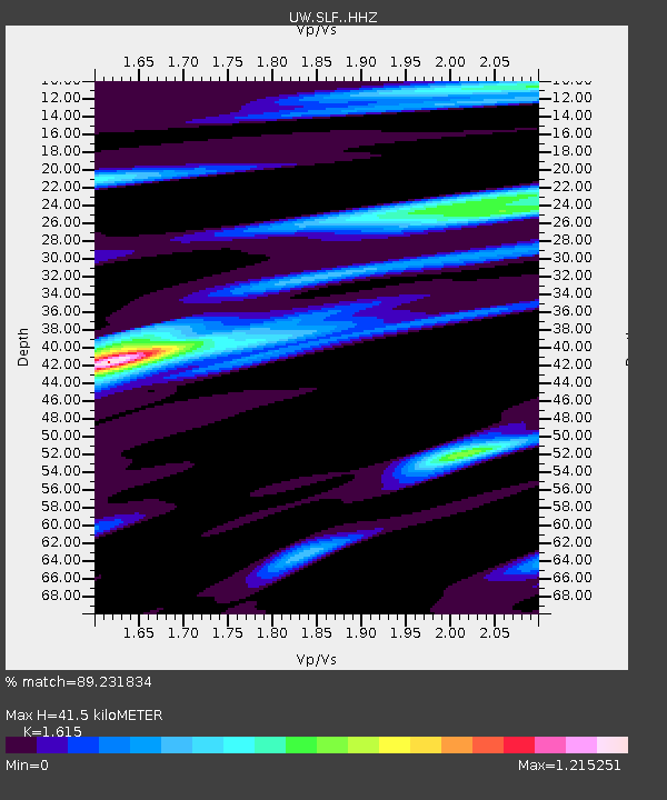
| Estimated Moho Depth: |
41.5 km |
| Estimated Crust Vp/Vs: |
1.62 |
| Assumed Crust Vp: |
6.597 km/s |
| Estimated Crust Vs: |
4.085 km/s |
| Estimated Crust Poisson's Ratio: |
0.19 |
|
| Radial Match: |
89.231834 % |
| Radial Bump: |
400 |
| Transverse Match: |
81.7698 % |
| Transverse Bump: |
400 |
| SOD ConfigId: |
27527651 |
| Insert Time: |
2022-06-09 16:08:27.376 +0000 |
| GWidth: |
2.5 |
| Max Bumps: |
400 |
| Tol: |
0.001 |
|

Signal To Noise
| Channel | StoN | STA | LTA |
| UW:SLF: :HHZ:20220526T15:50:43.51001Z | 24.622704 | 1.6514069E-6 | 6.706847E-8 |
| UW:SLF: :HHN:20220526T15:50:43.51001Z | 5.917551 | 2.4964206E-7 | 4.218672E-8 |
| UW:SLF: :HHE:20220526T15:50:43.51001Z | 4.894388 | 2.636736E-7 | 5.3872636E-8 |
| Arrivals |
| Ps | 4.0 SECOND |
| PpPs | 16 SECOND |
| PsPs/PpSs | 20 SECOND |


