You are here: Home > Network List > NE - New England Seismic Network Stations List
> Station EMMW Machias, ME > Earthquake Result Viewer
EMMW Machias, ME - Earthquake Result Viewer
*The percent match for this event was below the threshold and hence no stack was calculated.
| Earthquake location: |
Near Coast Of Guatemala |
| Earthquake latitude/longitude: |
13.6/-90.6 |
| Earthquake time(UTC): |
2008/04/15 (106) 03:03:04 GMT |
| Earthquake Depth: |
33 km |
| Earthquake Magnitude: |
5.6 MB, 5.8 MS, 6.1 MW, 6.1 MW |
| Earthquake Catalog/Contributor: |
WHDF/NEIC |
|
| Network: |
NE New England Seismic Network |
| Station: |
EMMW Machias, ME |
| Lat/Lon: |
44.71 N/67.46 W |
| Elevation: |
34 m |
|
| Distance: |
36.8 deg |
| Az: |
27.91 deg |
| Baz: |
219.672 deg |
| Ray Param: |
$rayparam |
*The percent match for this event was below the threshold and hence was not used in the summary stack. |
|
| Radial Match: |
59.805004 % |
| Radial Bump: |
400 |
| Transverse Match: |
47.338753 % |
| Transverse Bump: |
400 |
| SOD ConfigId: |
2504 |
| Insert Time: |
2010-03-09 20:22:41.687 +0000 |
| GWidth: |
2.5 |
| Max Bumps: |
400 |
| Tol: |
0.001 |
|
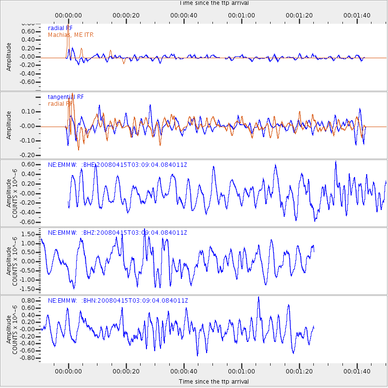
Signal To Noise
| Channel | StoN | STA | LTA |
| NE:EMMW: :BHZ:20080415T03:09:04.084011Z | 1.9311116 | 9.2428115E-7 | 4.786265E-7 |
| NE:EMMW: :BHN:20080415T03:09:04.084011Z | 1.321176 | 3.2871694E-7 | 2.488063E-7 |
| NE:EMMW: :BHE:20080415T03:09:04.084011Z | 0.6924727 | 1.60052E-7 | 2.3113112E-7 |
| Arrivals |
| Ps | |
| PpPs | |
| PsPs/PpSs | |


