You are here: Home > Network List > NE - New England Seismic Network Stations List
> Station EMMW Machias, ME > Earthquake Result Viewer
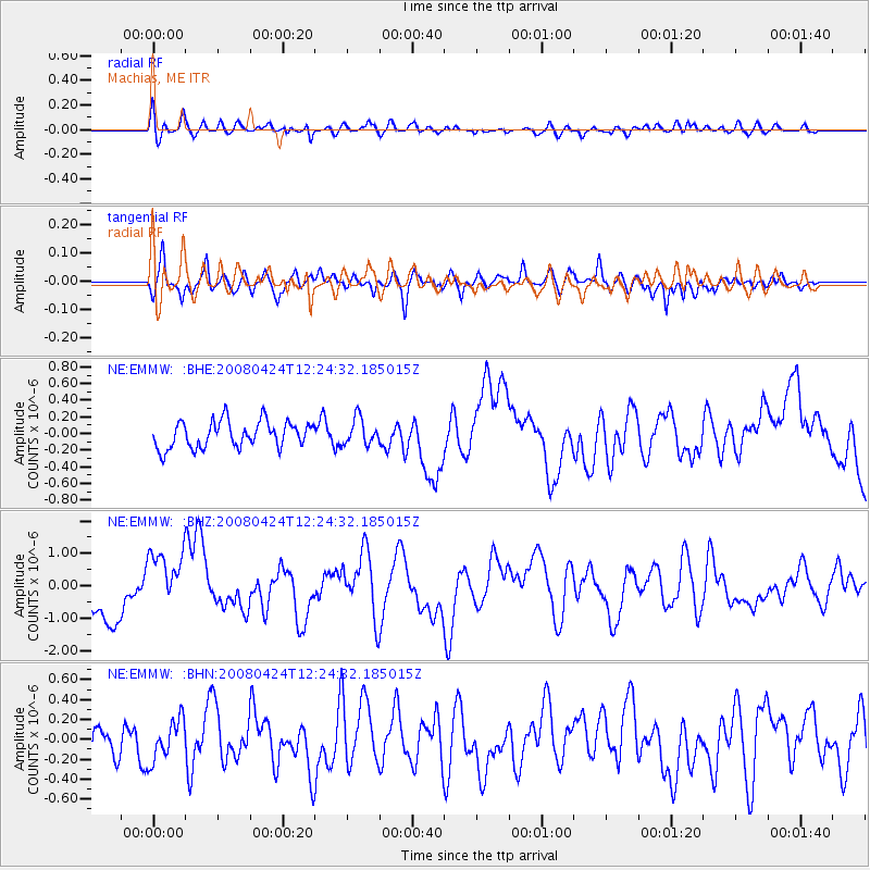
EMMW Machias, ME - Earthquake Result Viewer
*The percent match for this event was below the threshold and hence no stack was calculated.
| Earthquake location: |
Central Mid-Atlantic Ridge |
| Earthquake latitude/longitude: |
-1.2/-23.5 |
| Earthquake time(UTC): |
2008/04/24 (115) 12:14:49 GMT |
| Earthquake Depth: |
10 km |
| Earthquake Magnitude: |
6.0 MS, 5.4 MB, 6.5 MW, 6.4 MW |
| Earthquake Catalog/Contributor: |
WHDF/NEIC |
|
| Network: |
NE New England Seismic Network |
| Station: |
EMMW Machias, ME |
| Lat/Lon: |
44.71 N/67.46 W |
| Elevation: |
34 m |
|
| Distance: |
60.1 deg |
| Az: |
325.162 deg |
| Baz: |
126.775 deg |
| Ray Param: |
$rayparam |
*The percent match for this event was below the threshold and hence was not used in the summary stack. |
|
| Radial Match: |
63.876904 % |
| Radial Bump: |
400 |
| Transverse Match: |
56.060215 % |
| Transverse Bump: |
400 |
| SOD ConfigId: |
2504 |
| Insert Time: |
2010-03-09 20:22:43.542 +0000 |
| GWidth: |
2.5 |
| Max Bumps: |
400 |
| Tol: |
0.001 |
|
Signal To Noise
| Channel | StoN | STA | LTA |
| NE:EMMW: :BHZ:20080424T12:24:32.185015Z | 1.699864 | 1.0537315E-6 | 6.1989164E-7 |
| NE:EMMW: :BHN:20080424T12:24:32.185015Z | 1.1173687 | 2.064908E-7 | 1.8480095E-7 |
| NE:EMMW: :BHE:20080424T12:24:32.185015Z | 0.89505786 | 1.5149627E-7 | 1.6925864E-7 |
| Arrivals |
| Ps | |
| PpPs | |
| PsPs/PpSs | |


