You are here: Home > Network List > NE - New England Seismic Network Stations List
> Station EMMW Machias, ME > Earthquake Result Viewer
EMMW Machias, ME - Earthquake Result Viewer
*The percent match for this event was below the threshold and hence no stack was calculated.
| Earthquake location: |
Central Mid-Atlantic Ridge |
| Earthquake latitude/longitude: |
7.3/-34.9 |
| Earthquake time(UTC): |
2008/05/23 (144) 19:35:34 GMT |
| Earthquake Depth: |
9.0 km |
| Earthquake Magnitude: |
6.0 MB, 6.4 MS, 6.5 MW, 6.5 MW |
| Earthquake Catalog/Contributor: |
WHDF/NEIC |
|
| Network: |
NE New England Seismic Network |
| Station: |
EMMW Machias, ME |
| Lat/Lon: |
44.71 N/67.46 W |
| Elevation: |
34 m |
|
| Distance: |
46.8 deg |
| Az: |
328.224 deg |
| Baz: |
132.895 deg |
| Ray Param: |
$rayparam |
*The percent match for this event was below the threshold and hence was not used in the summary stack. |
|
| Radial Match: |
61.996532 % |
| Radial Bump: |
400 |
| Transverse Match: |
61.764767 % |
| Transverse Bump: |
400 |
| SOD ConfigId: |
2504 |
| Insert Time: |
2010-03-09 20:22:44.968 +0000 |
| GWidth: |
2.5 |
| Max Bumps: |
400 |
| Tol: |
0.001 |
|
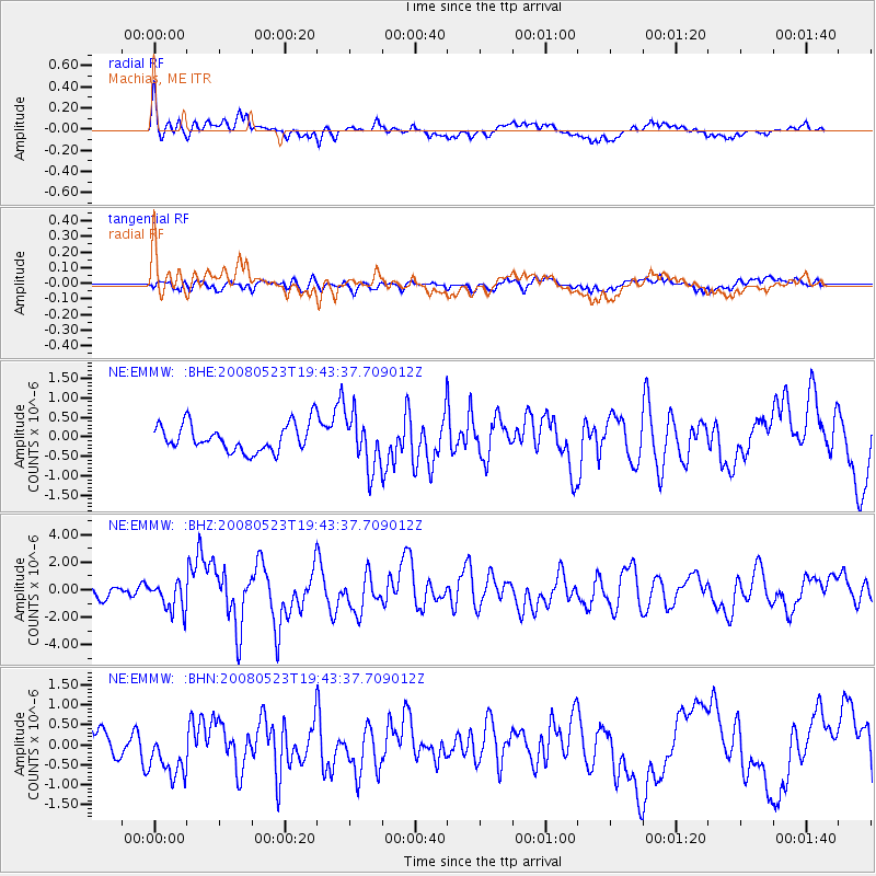
Signal To Noise
| Channel | StoN | STA | LTA |
| NE:EMMW: :BHZ:20080523T19:43:37.709012Z | 1.8320457 | 1.040172E-6 | 5.6776537E-7 |
| NE:EMMW: :BHN:20080523T19:43:37.709012Z | 2.2385185 | 6.0817456E-7 | 2.7168616E-7 |
| NE:EMMW: :BHE:20080523T19:43:37.709012Z | 2.4408052 | 7.524204E-7 | 3.0826732E-7 |
| Arrivals |
| Ps | |
| PpPs | |
| PsPs/PpSs | |


