You are here: Home > Network List > TX - Texas Seismological Network Stations List
> Station WTFS Witchita Falls > Earthquake Result Viewer
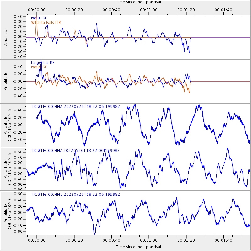
WTFS Witchita Falls - Earthquake Result Viewer
*The percent match for this event was below the threshold and hence no stack was calculated.
| Earthquake location: |
Southern East Pacific Rise |
| Earthquake latitude/longitude: |
-49.8/-114.9 |
| Earthquake time(UTC): |
2022/05/26 (146) 18:10:04 GMT |
| Earthquake Depth: |
10 km |
| Earthquake Magnitude: |
6.2 Mww |
| Earthquake Catalog/Contributor: |
NEIC PDE/us |
|
| Network: |
TX Texas Seismological Network |
| Station: |
WTFS Witchita Falls |
| Lat/Lon: |
33.77 N/98.46 W |
| Elevation: |
277 m |
|
| Distance: |
84.5 deg |
| Az: |
13.675 deg |
| Baz: |
190.6 deg |
| Ray Param: |
$rayparam |
*The percent match for this event was below the threshold and hence was not used in the summary stack. |
|
| Radial Match: |
59.323997 % |
| Radial Bump: |
400 |
| Transverse Match: |
78.719696 % |
| Transverse Bump: |
400 |
| SOD ConfigId: |
27527651 |
| Insert Time: |
2022-06-09 18:25:21.845 +0000 |
| GWidth: |
2.5 |
| Max Bumps: |
400 |
| Tol: |
0.001 |
|
Signal To Noise
| Channel | StoN | STA | LTA |
| TX:WTFS:00:HHZ:20220526T18:22:06.19998Z | 0.7574677 | 9.462603E-8 | 1.2492418E-7 |
| TX:WTFS:00:HH1:20220526T18:22:06.19998Z | 1.4316243 | 1.922227E-7 | 1.3426894E-7 |
| TX:WTFS:00:HH2:20220526T18:22:06.19998Z | 0.5118768 | 1.03994786E-7 | 2.031637E-7 |
| Arrivals |
| Ps | |
| PpPs | |
| PsPs/PpSs | |


