You are here: Home > Network List > GS - US Geological Survey Networks Stations List
> Station OK051 E0350 and S34600 roads, Ralston OK > Earthquake Result Viewer
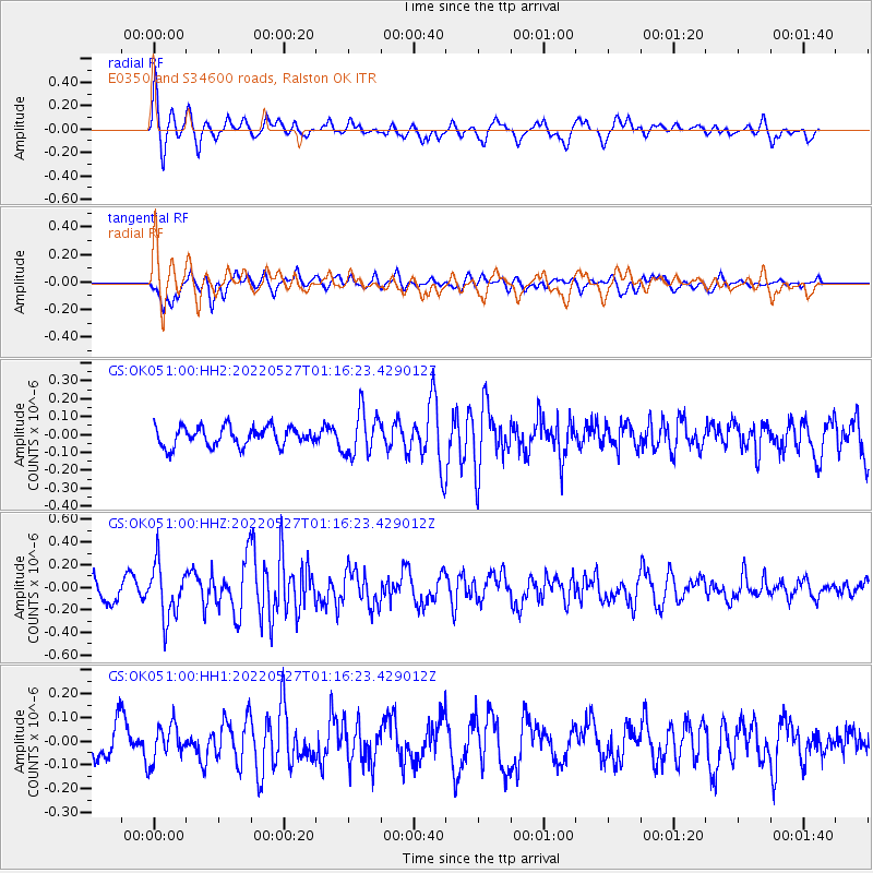
OK051 E0350 and S34600 roads, Ralston OK - Earthquake Result Viewer

| Earthquake location: |
Near Coast Of Peru |
| Earthquake latitude/longitude: |
-14.3/-75.7 |
| Earthquake time(UTC): |
2022/05/27 (147) 01:07:31 GMT |
| Earthquake Depth: |
39 km |
| Earthquake Magnitude: |
5.5 mww |
| Earthquake Catalog/Contributor: |
NEIC PDE/us |
|
| Network: |
GS US Geological Survey Networks |
| Station: |
OK051 E0350 and S34600 roads, Ralston OK |
| Lat/Lon: |
36.50 N/96.84 W |
| Elevation: |
263 m |
|
| Distance: |
54.3 deg |
| Az: |
339.037 deg |
| Baz: |
154.503 deg |
| Ray Param: |
0.06545043 |
| Estimated Moho Depth: |
67.0 km |
| Estimated Crust Vp/Vs: |
2.05 |
| Assumed Crust Vp: |
6.483 km/s |
| Estimated Crust Vs: |
3.158 km/s |
| Estimated Crust Poisson's Ratio: |
0.34 |
|
| Radial Match: |
80.61743 % |
| Radial Bump: |
391 |
| Transverse Match: |
75.7332 % |
| Transverse Bump: |
400 |
| SOD ConfigId: |
27527651 |
| Insert Time: |
2022-06-10 01:20:25.964 +0000 |
| GWidth: |
2.5 |
| Max Bumps: |
400 |
| Tol: |
0.001 |
|
Signal To Noise
| Channel | StoN | STA | LTA |
| GS:OK051:00:HHZ:20220527T01:16:23.429012Z | 3.2018046 | 2.371546E-7 | 7.406904E-8 |
| GS:OK051:00:HH1:20220527T01:16:23.429012Z | 1.0959673 | 7.6367435E-8 | 6.96804E-8 |
| GS:OK051:00:HH2:20220527T01:16:23.429012Z | 2.2848706 | 1.2232091E-7 | 5.3535164E-8 |
| Arrivals |
| Ps | 11 SECOND |
| PpPs | 30 SECOND |
| PsPs/PpSs | 42 SECOND |


