You are here: Home > Network List > NE - New England Seismic Network Stations List
> Station PQI Presque Isle, ME > Earthquake Result Viewer
PQI Presque Isle, ME - Earthquake Result Viewer
| Earthquake location: |
Panama |
| Earthquake latitude/longitude: |
9.6/-79.0 |
| Earthquake time(UTC): |
2009/07/04 (185) 06:49:35 GMT |
| Earthquake Depth: |
38 km |
| Earthquake Magnitude: |
6.0 MB, 5.5 MS, 6.0 MW, 6.0 MW |
| Earthquake Catalog/Contributor: |
WHDF/NEIC |
|
| Network: |
NE New England Seismic Network |
| Station: |
PQI Presque Isle, ME |
| Lat/Lon: |
46.67 N/68.01 W |
| Elevation: |
175 m |
|
| Distance: |
38.1 deg |
| Az: |
12.238 deg |
| Baz: |
197.673 deg |
| Ray Param: |
0.07566665 |
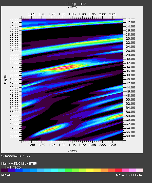
| Estimated Moho Depth: |
35.0 km |
| Estimated Crust Vp/Vs: |
1.79 |
| Assumed Crust Vp: |
6.419 km/s |
| Estimated Crust Vs: |
3.581 km/s |
| Estimated Crust Poisson's Ratio: |
0.27 |
|
| Radial Match: |
84.6327 % |
| Radial Bump: |
400 |
| Transverse Match: |
68.8612 % |
| Transverse Bump: |
400 |
| SOD ConfigId: |
2622 |
| Insert Time: |
2010-03-09 20:24:03.464 +0000 |
| GWidth: |
2.5 |
| Max Bumps: |
400 |
| Tol: |
0.001 |
|
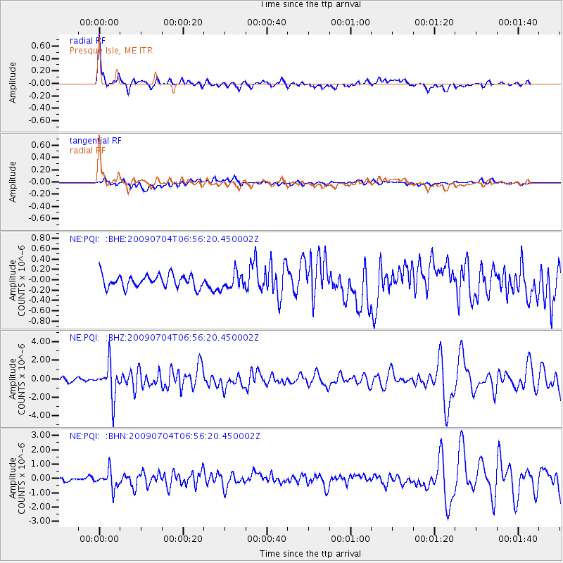
Signal To Noise
| Channel | StoN | STA | LTA |
| NE:PQI: :BHZ:20090704T06:56:20.450002Z | 9.478016 | 1.8202422E-6 | 1.9204887E-7 |
| NE:PQI: :BHN:20090704T06:56:20.450002Z | 3.4491472 | 6.2797545E-7 | 1.8206687E-7 |
| NE:PQI: :BHE:20090704T06:56:20.450002Z | 1.2320533 | 1.4967064E-7 | 1.2148065E-7 |
| Arrivals |
| Ps | 4.6 SECOND |
| PpPs | 14 SECOND |
| PsPs/PpSs | 19 SECOND |


