You are here: Home > Network List > NE - New England Seismic Network Stations List
> Station PQI Presque Isle, ME > Earthquake Result Viewer
PQI Presque Isle, ME - Earthquake Result Viewer

| Earthquake location: |
Near Coast Of Chiapas, Mexico |
| Earthquake latitude/longitude: |
14.3/-92.6 |
| Earthquake time(UTC): |
2008/10/16 (290) 19:43:37 GMT |
| Earthquake Depth: |
23 km |
| Earthquake Magnitude: |
5.8 MB |
| Earthquake Catalog/Contributor: |
WHDF/NEIC |
|
| Network: |
NE New England Seismic Network |
| Station: |
PQI Presque Isle, ME |
| Lat/Lon: |
46.67 N/68.01 W |
| Elevation: |
175 m |
|
| Distance: |
38.3 deg |
| Az: |
27.485 deg |
| Baz: |
220.528 deg |
| Ray Param: |
0.075608976 |
| Estimated Moho Depth: |
66.0 km |
| Estimated Crust Vp/Vs: |
1.77 |
| Assumed Crust Vp: |
6.419 km/s |
| Estimated Crust Vs: |
3.627 km/s |
| Estimated Crust Poisson's Ratio: |
0.27 |
|
| Radial Match: |
84.958885 % |
| Radial Bump: |
400 |
| Transverse Match: |
35.5888 % |
| Transverse Bump: |
400 |
| SOD ConfigId: |
2556 |
| Insert Time: |
2010-03-09 20:24:09.493 +0000 |
| GWidth: |
2.5 |
| Max Bumps: |
400 |
| Tol: |
0.001 |
|
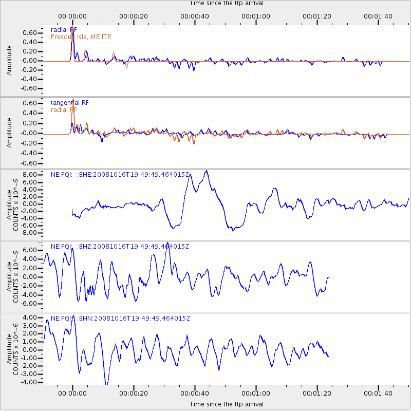
Signal To Noise
| Channel | StoN | STA | LTA |
| NE:PQI: :BHZ:20081016T19:49:49.464015Z | 0.6608578 | 4.0138343E-6 | 6.073673E-6 |
| NE:PQI: :BHN:20081016T19:49:49.464015Z | 0.8539472 | 2.3895732E-6 | 2.798268E-6 |
| NE:PQI: :BHE:20081016T19:49:49.464015Z | 0.4295178 | 2.1406604E-6 | 4.983869E-6 |
| Arrivals |
| Ps | 8.5 SECOND |
| PpPs | 26 SECOND |
| PsPs/PpSs | 35 SECOND |


