You are here: Home > Network List > NE - New England Seismic Network Stations List
> Station PQI Presque Isle, ME > Earthquake Result Viewer
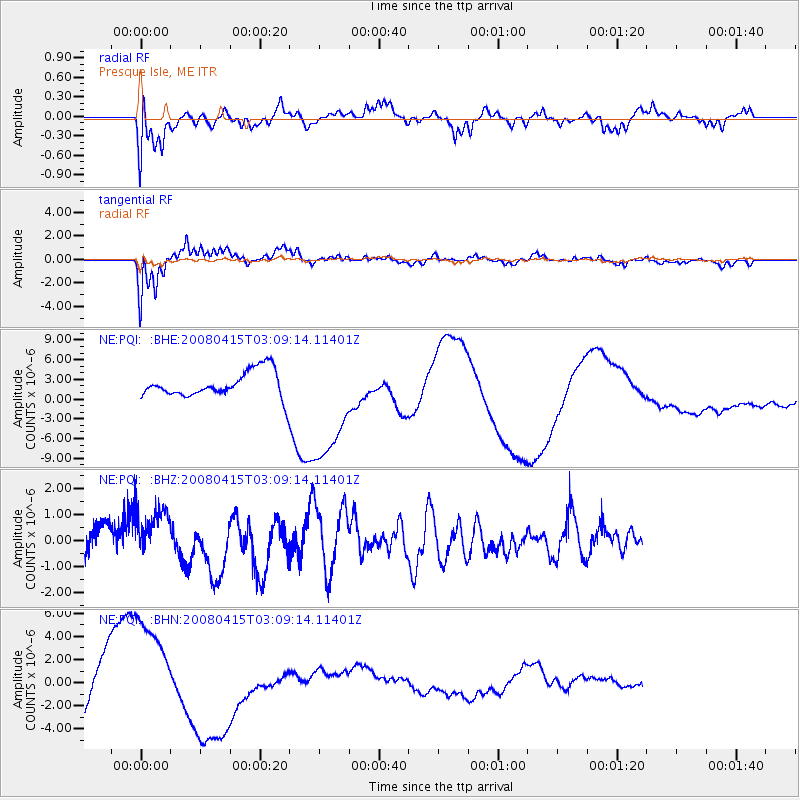
PQI Presque Isle, ME - Earthquake Result Viewer
*The percent match for this event was below the threshold and hence no stack was calculated.
| Earthquake location: |
Near Coast Of Guatemala |
| Earthquake latitude/longitude: |
13.6/-90.6 |
| Earthquake time(UTC): |
2008/04/15 (106) 03:03:04 GMT |
| Earthquake Depth: |
33 km |
| Earthquake Magnitude: |
5.6 MB, 5.8 MS, 6.1 MW, 6.1 MW |
| Earthquake Catalog/Contributor: |
WHDF/NEIC |
|
| Network: |
NE New England Seismic Network |
| Station: |
PQI Presque Isle, ME |
| Lat/Lon: |
46.67 N/68.01 W |
| Elevation: |
175 m |
|
| Distance: |
38.1 deg |
| Az: |
25.401 deg |
| Baz: |
217.283 deg |
| Ray Param: |
$rayparam |
*The percent match for this event was below the threshold and hence was not used in the summary stack. |
|
| Radial Match: |
49.25304 % |
| Radial Bump: |
400 |
| Transverse Match: |
80.71982 % |
| Transverse Bump: |
400 |
| SOD ConfigId: |
2504 |
| Insert Time: |
2010-03-09 20:24:38.000 +0000 |
| GWidth: |
2.5 |
| Max Bumps: |
400 |
| Tol: |
0.001 |
|
Signal To Noise
| Channel | StoN | STA | LTA |
| NE:PQI: :BHZ:20080415T03:09:14.11401Z | 1.697322 | 1.1047154E-6 | 6.508579E-7 |
| NE:PQI: :BHN:20080415T03:09:14.11401Z | 2.3666236 | 5.7272005E-6 | 2.4199878E-6 |
| NE:PQI: :BHE:20080415T03:09:14.11401Z | 2.2420177 | 9.760843E-6 | 4.353597E-6 |
| Arrivals |
| Ps | |
| PpPs | |
| PsPs/PpSs | |


