You are here: Home > Network List > NE - New England Seismic Network Stations List
> Station PQI Presque Isle, ME > Earthquake Result Viewer
PQI Presque Isle, ME - Earthquake Result Viewer
*The percent match for this event was below the threshold and hence no stack was calculated.
| Earthquake location: |
Western Brazil |
| Earthquake latitude/longitude: |
-8.1/-71.4 |
| Earthquake time(UTC): |
2009/01/29 (029) 22:28:05 GMT |
| Earthquake Depth: |
602 km |
| Earthquake Magnitude: |
5.7 MW, 5.3 MB, 5.6 MW |
| Earthquake Catalog/Contributor: |
WHDF/NEIC |
|
| Network: |
NE New England Seismic Network |
| Station: |
PQI Presque Isle, ME |
| Lat/Lon: |
46.67 N/68.01 W |
| Elevation: |
175 m |
|
| Distance: |
54.6 deg |
| Az: |
2.862 deg |
| Baz: |
184.117 deg |
| Ray Param: |
$rayparam |
*The percent match for this event was below the threshold and hence was not used in the summary stack. |
|
| Radial Match: |
35.399754 % |
| Radial Bump: |
400 |
| Transverse Match: |
24.477177 % |
| Transverse Bump: |
400 |
| SOD ConfigId: |
2658 |
| Insert Time: |
2010-03-09 20:24:42.027 +0000 |
| GWidth: |
2.5 |
| Max Bumps: |
400 |
| Tol: |
0.001 |
|
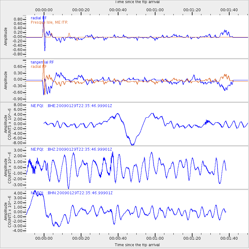
Signal To Noise
| Channel | StoN | STA | LTA |
| NE:PQI: :BHZ:20090129T22:35:46.99901Z | 1.179576 | 1.106583E-6 | 9.381192E-7 |
| NE:PQI: :BHN:20090129T22:35:46.99901Z | 1.1625848 | 1.9711492E-6 | 1.6954885E-6 |
| NE:PQI: :BHE:20090129T22:35:46.99901Z | 1.2838118 | 3.0706394E-6 | 2.3918142E-6 |
| Arrivals |
| Ps | |
| PpPs | |
| PsPs/PpSs | |


