You are here: Home > Network List > AK - Alaska Regional Network Stations List
> Station F20K Avaraart Lake, AK, USA > Earthquake Result Viewer
F20K Avaraart Lake, AK, USA - Earthquake Result Viewer
| Earthquake location: |
Timor Region |
| Earthquake latitude/longitude: |
-8.3/127.2 |
| Earthquake time(UTC): |
2022/05/27 (147) 02:36:05 GMT |
| Earthquake Depth: |
51 km |
| Earthquake Magnitude: |
6.1 Mww |
| Earthquake Catalog/Contributor: |
NEIC PDE/us |
|
| Network: |
AK Alaska Regional Network |
| Station: |
F20K Avaraart Lake, AK, USA |
| Lat/Lon: |
67.05 N/155.73 W |
| Elevation: |
136 m |
|
| Distance: |
92.6 deg |
| Az: |
22.495 deg |
| Baz: |
254.923 deg |
| Ray Param: |
0.04141864 |
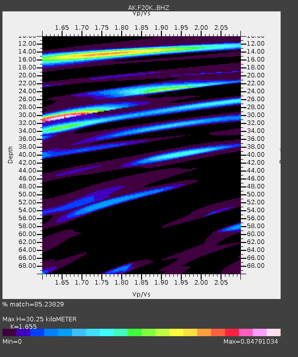
| Estimated Moho Depth: |
30.25 km |
| Estimated Crust Vp/Vs: |
1.65 |
| Assumed Crust Vp: |
6.522 km/s |
| Estimated Crust Vs: |
3.941 km/s |
| Estimated Crust Poisson's Ratio: |
0.21 |
|
| Radial Match: |
85.23829 % |
| Radial Bump: |
400 |
| Transverse Match: |
82.541695 % |
| Transverse Bump: |
348 |
| SOD ConfigId: |
27527651 |
| Insert Time: |
2022-06-10 02:38:30.794 +0000 |
| GWidth: |
2.5 |
| Max Bumps: |
400 |
| Tol: |
0.001 |
|

Signal To Noise
| Channel | StoN | STA | LTA |
| AK:F20K: :BHZ:20220527T02:48:40.139991Z | 6.2886457 | 3.5984885E-7 | 5.7221996E-8 |
| AK:F20K: :BHN:20220527T02:48:40.139991Z | 2.4241579 | 1.0008535E-7 | 4.1286647E-8 |
| AK:F20K: :BHE:20220527T02:48:40.139991Z | 4.7659993 | 1.3832631E-7 | 2.902357E-8 |
| Arrivals |
| Ps | 3.1 SECOND |
| PpPs | 12 SECOND |
| PsPs/PpSs | 15 SECOND |


