You are here: Home > Network List > NE - New England Seismic Network Stations List
> Station PQI Presque Isle, ME > Earthquake Result Viewer
PQI Presque Isle, ME - Earthquake Result Viewer
*The percent match for this event was below the threshold and hence no stack was calculated.
| Earthquake location: |
Kuril Islands |
| Earthquake latitude/longitude: |
46.0/151.5 |
| Earthquake time(UTC): |
2009/04/07 (097) 04:23:33 GMT |
| Earthquake Depth: |
31 km |
| Earthquake Magnitude: |
6.5 MB, 6.8 MS, 6.9 MW, 6.9 MW |
| Earthquake Catalog/Contributor: |
WHDF/NEIC |
|
| Network: |
NE New England Seismic Network |
| Station: |
PQI Presque Isle, ME |
| Lat/Lon: |
46.67 N/68.01 W |
| Elevation: |
175 m |
|
| Distance: |
81.3 deg |
| Az: |
26.337 deg |
| Baz: |
333.34 deg |
| Ray Param: |
$rayparam |
*The percent match for this event was below the threshold and hence was not used in the summary stack. |
|
| Radial Match: |
34.72099 % |
| Radial Bump: |
351 |
| Transverse Match: |
49.11099 % |
| Transverse Bump: |
400 |
| SOD ConfigId: |
2658 |
| Insert Time: |
2010-03-09 20:24:50.005 +0000 |
| GWidth: |
2.5 |
| Max Bumps: |
400 |
| Tol: |
0.001 |
|
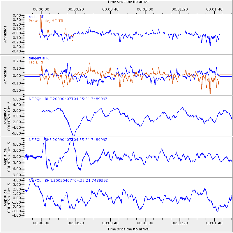
Signal To Noise
| Channel | StoN | STA | LTA |
| NE:PQI: :BHZ:20090407T04:35:21.748999Z | 8.583843 | 4.490764E-6 | 5.231647E-7 |
| NE:PQI: :BHN:20090407T04:35:21.748999Z | 0.6592007 | 1.3956169E-6 | 2.117135E-6 |
| NE:PQI: :BHE:20090407T04:35:21.748999Z | 0.6734923 | 1.7180901E-6 | 2.5510167E-6 |
| Arrivals |
| Ps | |
| PpPs | |
| PsPs/PpSs | |


