You are here: Home > Network List > US - United States National Seismic Network Stations List
> Station WMOK Wichita Mountains, Oklahoma, USA > Earthquake Result Viewer
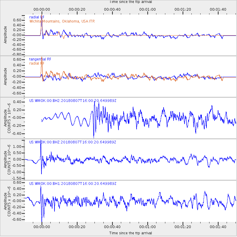
WMOK Wichita Mountains, Oklahoma, USA - Earthquake Result Viewer
*The percent match for this event was below the threshold and hence no stack was calculated.
| Earthquake location: |
Northern Colombia |
| Earthquake latitude/longitude: |
6.8/-73.0 |
| Earthquake time(UTC): |
2018/08/07 (219) 15:53:59 GMT |
| Earthquake Depth: |
148 km |
| Earthquake Magnitude: |
5.6 mb |
| Earthquake Catalog/Contributor: |
NEIC PDE/us |
|
| Network: |
US United States National Seismic Network |
| Station: |
WMOK Wichita Mountains, Oklahoma, USA |
| Lat/Lon: |
34.74 N/98.78 W |
| Elevation: |
486 m |
|
| Distance: |
36.6 deg |
| Az: |
323.048 deg |
| Baz: |
133.54 deg |
| Ray Param: |
$rayparam |
*The percent match for this event was below the threshold and hence was not used in the summary stack. |
|
| Radial Match: |
68.08068 % |
| Radial Bump: |
400 |
| Transverse Match: |
54.733845 % |
| Transverse Bump: |
400 |
| SOD ConfigId: |
2778632 |
| Insert Time: |
2018-08-21 16:01:18.740 +0000 |
| GWidth: |
2.5 |
| Max Bumps: |
400 |
| Tol: |
0.001 |
|
Signal To Noise
| Channel | StoN | STA | LTA |
| US:WMOK:00:BHZ:20180807T16:00:20.649989Z | 6.9043756 | 4.507977E-7 | 6.5291594E-8 |
| US:WMOK:00:BH1:20180807T16:00:20.649989Z | 2.191706 | 2.3570628E-7 | 1.0754467E-7 |
| US:WMOK:00:BH2:20180807T16:00:20.649989Z | 2.5687857 | 2.1677971E-7 | 8.438996E-8 |
| Arrivals |
| Ps | |
| PpPs | |
| PsPs/PpSs | |


