You are here: Home > Network List > NE - New England Seismic Network Stations List
> Station PQI Presque Isle, ME > Earthquake Result Viewer
PQI Presque Isle, ME - Earthquake Result Viewer
*The percent match for this event was below the threshold and hence no stack was calculated.
| Earthquake location: |
Pakistan |
| Earthquake latitude/longitude: |
30.6/67.5 |
| Earthquake time(UTC): |
2008/10/29 (303) 11:32:43 GMT |
| Earthquake Depth: |
14 km |
| Earthquake Magnitude: |
6.2 MB, 6.6 MS, 6.4 MW, 6.4 MW |
| Earthquake Catalog/Contributor: |
WHDF/NEIC |
|
| Network: |
NE New England Seismic Network |
| Station: |
PQI Presque Isle, ME |
| Lat/Lon: |
46.67 N/68.01 W |
| Elevation: |
175 m |
|
| Distance: |
93.2 deg |
| Az: |
331.073 deg |
| Baz: |
37.276 deg |
| Ray Param: |
$rayparam |
*The percent match for this event was below the threshold and hence was not used in the summary stack. |
|
| Radial Match: |
52.867737 % |
| Radial Bump: |
400 |
| Transverse Match: |
49.33957 % |
| Transverse Bump: |
400 |
| SOD ConfigId: |
2560 |
| Insert Time: |
2010-03-09 20:25:12.736 +0000 |
| GWidth: |
2.5 |
| Max Bumps: |
400 |
| Tol: |
0.001 |
|
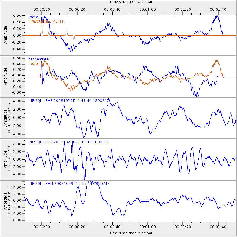
Signal To Noise
| Channel | StoN | STA | LTA |
| NE:PQI: :BHZ:20081029T11:45:44.189021Z | 1.1461434 | 1.3762025E-6 | 1.2007245E-6 |
| NE:PQI: :BHN:20081029T11:45:44.189021Z | 1.9703132 | 1.6969606E-6 | 8.612643E-7 |
| NE:PQI: :BHE:20081029T11:45:44.189021Z | 3.3636162 | 1.8422963E-6 | 5.47713E-7 |
| Arrivals |
| Ps | |
| PpPs | |
| PsPs/PpSs | |


