You are here: Home > Network List > AV - Alaska Volcano Observatory Stations List
> Station AKS Akutan Strait, Akutan Volcano, Alaska > Earthquake Result Viewer
AKS Akutan Strait, Akutan Volcano, Alaska - Earthquake Result Viewer
| Earthquake location: |
Timor Region |
| Earthquake latitude/longitude: |
-8.3/127.2 |
| Earthquake time(UTC): |
2022/05/27 (147) 02:36:05 GMT |
| Earthquake Depth: |
51 km |
| Earthquake Magnitude: |
6.1 Mww |
| Earthquake Catalog/Contributor: |
NEIC PDE/us |
|
| Network: |
AV Alaska Volcano Observatory |
| Station: |
AKS Akutan Strait, Akutan Volcano, Alaska |
| Lat/Lon: |
54.11 N/165.70 W |
| Elevation: |
213 m |
|
| Distance: |
83.6 deg |
| Az: |
33.077 deg |
| Baz: |
246.546 deg |
| Ray Param: |
0.0459828 |
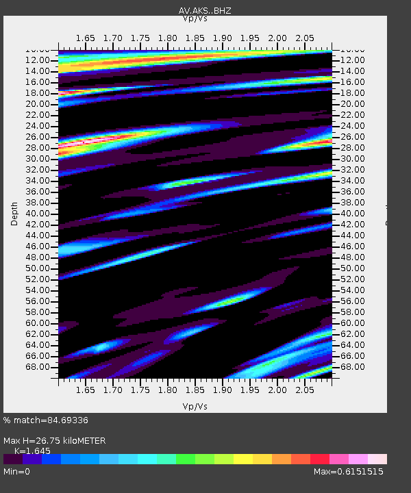
| Estimated Moho Depth: |
26.75 km |
| Estimated Crust Vp/Vs: |
1.64 |
| Assumed Crust Vp: |
5.989 km/s |
| Estimated Crust Vs: |
3.641 km/s |
| Estimated Crust Poisson's Ratio: |
0.21 |
|
| Radial Match: |
84.69336 % |
| Radial Bump: |
400 |
| Transverse Match: |
78.79503 % |
| Transverse Bump: |
400 |
| SOD ConfigId: |
27527651 |
| Insert Time: |
2022-06-10 02:41:34.435 +0000 |
| GWidth: |
2.5 |
| Max Bumps: |
400 |
| Tol: |
0.001 |
|

Signal To Noise
| Channel | StoN | STA | LTA |
| AV:AKS: :BHZ:20220527T02:47:57.340003Z | 3.857369 | 7.2672657E-7 | 1.8839954E-7 |
| AV:AKS: :BHN:20220527T02:47:57.340003Z | 1.3923008 | 3.0303957E-7 | 2.176538E-7 |
| AV:AKS: :BHE:20220527T02:47:57.340003Z | 1.8026922 | 2.9465411E-7 | 1.6345226E-7 |
| Arrivals |
| Ps | 2.9 SECOND |
| PpPs | 12 SECOND |
| PsPs/PpSs | 14 SECOND |


