You are here: Home > Network List > UU - University of Utah Regional Network Stations List
> Station HMU Henry Mountain, UT, USA > Earthquake Result Viewer
HMU Henry Mountain, UT, USA - Earthquake Result Viewer
| Earthquake location: |
Northern Colombia |
| Earthquake latitude/longitude: |
6.8/-73.0 |
| Earthquake time(UTC): |
2018/08/07 (219) 15:53:59 GMT |
| Earthquake Depth: |
148 km |
| Earthquake Magnitude: |
5.6 mb |
| Earthquake Catalog/Contributor: |
NEIC PDE/us |
|
| Network: |
UU University of Utah Regional Network |
| Station: |
HMU Henry Mountain, UT, USA |
| Lat/Lon: |
37.94 N/110.74 W |
| Elevation: |
2430 m |
|
| Distance: |
46.2 deg |
| Az: |
317.842 deg |
| Baz: |
122.542 deg |
| Ray Param: |
0.07029037 |
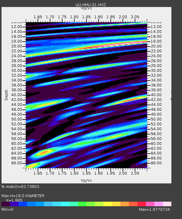
| Estimated Moho Depth: |
19.0 km |
| Estimated Crust Vp/Vs: |
1.99 |
| Assumed Crust Vp: |
6.247 km/s |
| Estimated Crust Vs: |
3.147 km/s |
| Estimated Crust Poisson's Ratio: |
0.33 |
|
| Radial Match: |
83.73903 % |
| Radial Bump: |
400 |
| Transverse Match: |
76.75639 % |
| Transverse Bump: |
400 |
| SOD ConfigId: |
2778632 |
| Insert Time: |
2018-08-21 16:01:40.129 +0000 |
| GWidth: |
2.5 |
| Max Bumps: |
400 |
| Tol: |
0.001 |
|

Signal To Noise
| Channel | StoN | STA | LTA |
| UU:HMU:01:HHZ:20180807T16:01:38.477992Z | 9.871878 | 4.6879705E-8 | 4.7488133E-9 |
| UU:HMU:01:HHN:20180807T16:01:38.477992Z | 15.479626 | 2.4693017E-8 | 1.5951948E-9 |
| UU:HMU:01:HHE:20180807T16:01:38.477992Z | 13.029112 | 5.3696464E-8 | 4.121268E-9 |
| Arrivals |
| Ps | 3.2 SECOND |
| PpPs | 8.6 SECOND |
| PsPs/PpSs | 12 SECOND |


