You are here: Home > Network List > AV - Alaska Volcano Observatory Stations List
> Station KOKL Mount Kliuchef, Korovin Volcano, Alaska > Earthquake Result Viewer
KOKL Mount Kliuchef, Korovin Volcano, Alaska - Earthquake Result Viewer
| Earthquake location: |
Timor Region |
| Earthquake latitude/longitude: |
-8.3/127.2 |
| Earthquake time(UTC): |
2022/05/27 (147) 02:36:05 GMT |
| Earthquake Depth: |
51 km |
| Earthquake Magnitude: |
6.1 Mww |
| Earthquake Catalog/Contributor: |
NEIC PDE/us |
|
| Network: |
AV Alaska Volcano Observatory |
| Station: |
KOKL Mount Kliuchef, Korovin Volcano, Alaska |
| Lat/Lon: |
52.32 N/174.20 W |
| Elevation: |
758 m |
|
| Distance: |
78.2 deg |
| Az: |
32.348 deg |
| Baz: |
239.631 deg |
| Ray Param: |
0.049689174 |
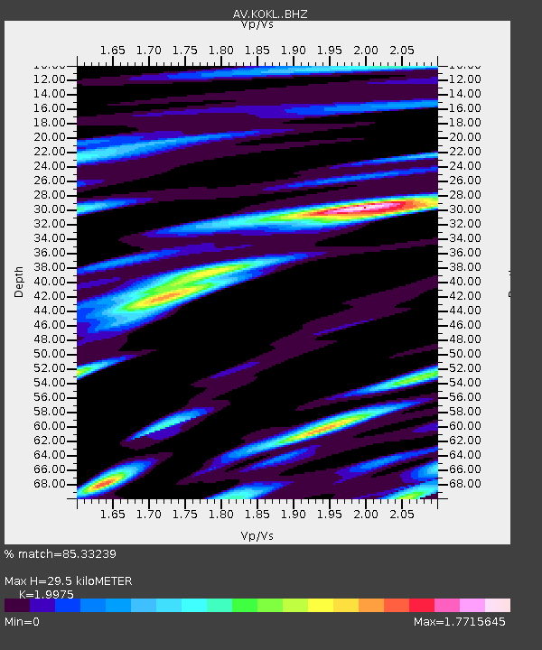
| Estimated Moho Depth: |
29.5 km |
| Estimated Crust Vp/Vs: |
2.00 |
| Assumed Crust Vp: |
5.88 km/s |
| Estimated Crust Vs: |
2.944 km/s |
| Estimated Crust Poisson's Ratio: |
0.33 |
|
| Radial Match: |
85.33239 % |
| Radial Bump: |
400 |
| Transverse Match: |
69.355576 % |
| Transverse Bump: |
400 |
| SOD ConfigId: |
27527651 |
| Insert Time: |
2022-06-10 02:42:32.842 +0000 |
| GWidth: |
2.5 |
| Max Bumps: |
400 |
| Tol: |
0.001 |
|

Signal To Noise
| Channel | StoN | STA | LTA |
| AV:KOKL: :BHZ:20220527T02:47:28.860023Z | 5.2907524 | 6.4985113E-7 | 1.2282774E-7 |
| AV:KOKL: :BHN:20220527T02:47:28.860023Z | 1.7353588 | 4.5518635E-7 | 2.6230097E-7 |
| AV:KOKL: :BHE:20220527T02:47:28.860023Z | 3.393899 | 7.625456E-7 | 2.2468129E-7 |
| Arrivals |
| Ps | 5.1 SECOND |
| PpPs | 15 SECOND |
| PsPs/PpSs | 20 SECOND |


