You are here: Home > Network List > AV - Alaska Volcano Observatory Stations List
> Station MAPS Pakushin Southeast, Makushin Volcano, Alaska > Earthquake Result Viewer
MAPS Pakushin Southeast, Makushin Volcano, Alaska - Earthquake Result Viewer
| Earthquake location: |
Timor Region |
| Earthquake latitude/longitude: |
-8.3/127.2 |
| Earthquake time(UTC): |
2022/05/27 (147) 02:36:05 GMT |
| Earthquake Depth: |
51 km |
| Earthquake Magnitude: |
6.1 Mww |
| Earthquake Catalog/Contributor: |
NEIC PDE/us |
|
| Network: |
AV Alaska Volcano Observatory |
| Station: |
MAPS Pakushin Southeast, Makushin Volcano, Alaska |
| Lat/Lon: |
53.81 N/166.94 W |
| Elevation: |
333 m |
|
| Distance: |
82.8 deg |
| Az: |
33.055 deg |
| Baz: |
245.541 deg |
| Ray Param: |
0.046543702 |
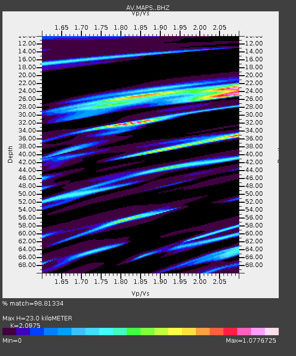
| Estimated Moho Depth: |
23.0 km |
| Estimated Crust Vp/Vs: |
2.10 |
| Assumed Crust Vp: |
3.943 km/s |
| Estimated Crust Vs: |
1.88 km/s |
| Estimated Crust Poisson's Ratio: |
0.35 |
|
| Radial Match: |
98.81334 % |
| Radial Bump: |
144 |
| Transverse Match: |
98.43052 % |
| Transverse Bump: |
174 |
| SOD ConfigId: |
27527651 |
| Insert Time: |
2022-06-10 02:42:41.168 +0000 |
| GWidth: |
2.5 |
| Max Bumps: |
400 |
| Tol: |
0.001 |
|
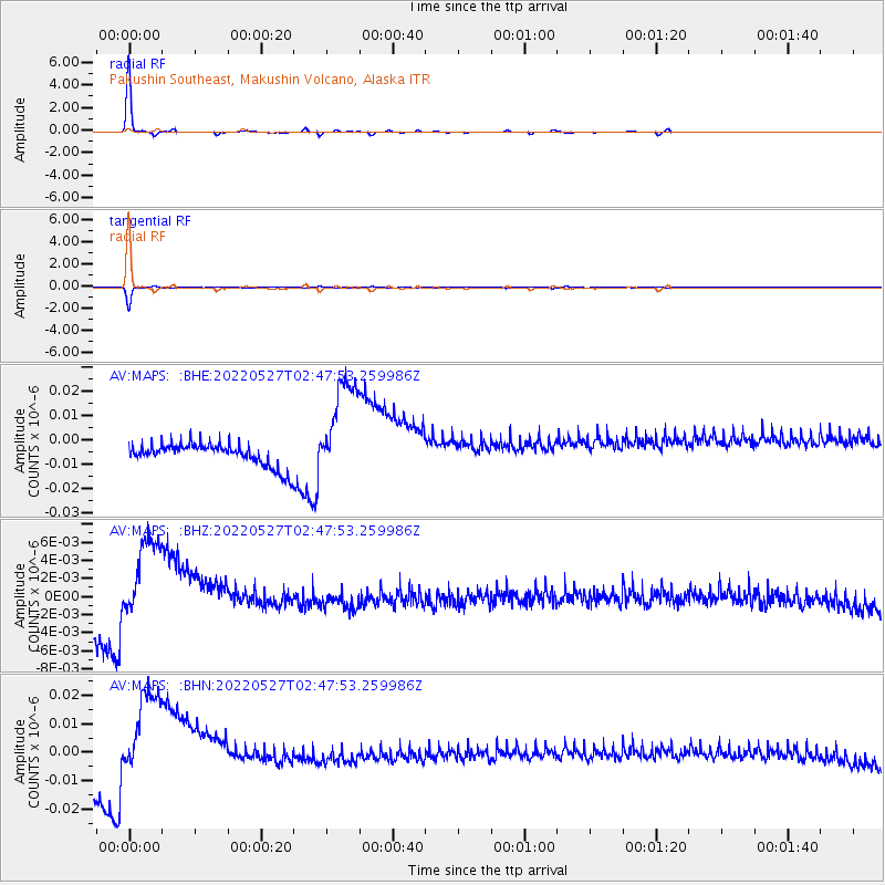
Signal To Noise
| Channel | StoN | STA | LTA |
| AV:MAPS: :BHZ:20220527T02:47:53.259986Z | 4.688515 | 5.7591785E-9 | 1.2283587E-9 |
| AV:MAPS: :BHN:20220527T02:47:53.259986Z | 4.824325 | 1.9802604E-8 | 4.104741E-9 |
| AV:MAPS: :BHE:20220527T02:47:53.259986Z | 4.7390532 | 2.1857215E-8 | 4.612148E-9 |
| Arrivals |
| Ps | 6.5 SECOND |
| PpPs | 18 SECOND |
| PsPs/PpSs | 24 SECOND |


