You are here: Home > Network List > AV - Alaska Volcano Observatory Stations List
> Station MNAT Nateekin Bay, Makushin Volcano, Alaska > Earthquake Result Viewer
MNAT Nateekin Bay, Makushin Volcano, Alaska - Earthquake Result Viewer
| Earthquake location: |
Timor Region |
| Earthquake latitude/longitude: |
-8.3/127.2 |
| Earthquake time(UTC): |
2022/05/27 (147) 02:36:05 GMT |
| Earthquake Depth: |
51 km |
| Earthquake Magnitude: |
6.1 Mww |
| Earthquake Catalog/Contributor: |
NEIC PDE/us |
|
| Network: |
AV Alaska Volcano Observatory |
| Station: |
MNAT Nateekin Bay, Makushin Volcano, Alaska |
| Lat/Lon: |
53.88 N/166.69 W |
| Elevation: |
390 m |
|
| Distance: |
83.0 deg |
| Az: |
33.049 deg |
| Baz: |
245.746 deg |
| Ray Param: |
0.046424285 |
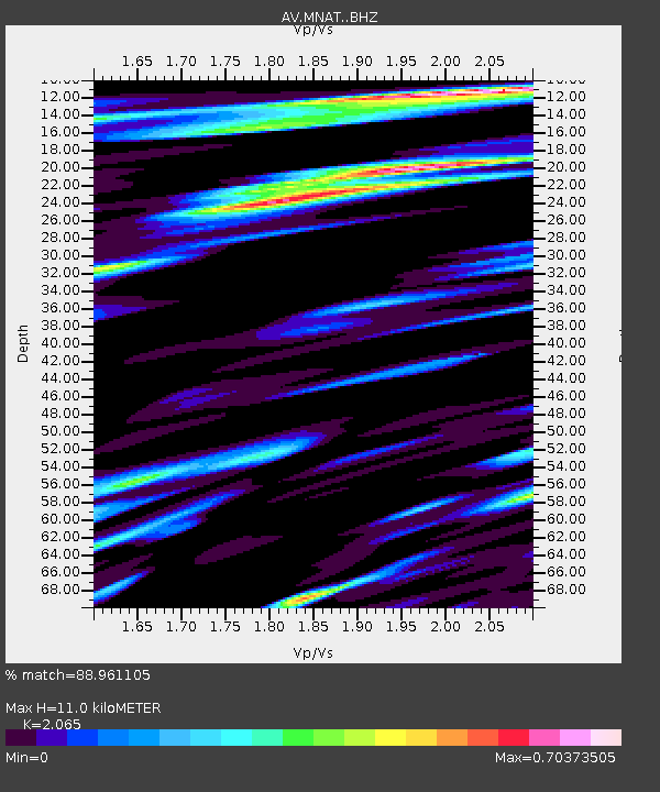
| Estimated Moho Depth: |
11.0 km |
| Estimated Crust Vp/Vs: |
2.07 |
| Assumed Crust Vp: |
3.943 km/s |
| Estimated Crust Vs: |
1.91 km/s |
| Estimated Crust Poisson's Ratio: |
0.35 |
|
| Radial Match: |
88.961105 % |
| Radial Bump: |
400 |
| Transverse Match: |
83.79592 % |
| Transverse Bump: |
400 |
| SOD ConfigId: |
27527651 |
| Insert Time: |
2022-06-10 02:42:47.563 +0000 |
| GWidth: |
2.5 |
| Max Bumps: |
400 |
| Tol: |
0.001 |
|

Signal To Noise
| Channel | StoN | STA | LTA |
| AV:MNAT: :BHZ:20220527T02:47:54.119972Z | 9.109502 | 5.4923424E-7 | 6.029246E-8 |
| AV:MNAT: :BHN:20220527T02:47:54.119972Z | 3.0183778 | 2.6145722E-7 | 8.662177E-8 |
| AV:MNAT: :BHE:20220527T02:47:54.119972Z | 2.1228063 | 1.7002229E-7 | 8.0093166E-8 |
| Arrivals |
| Ps | 3.0 SECOND |
| PpPs | 8.5 SECOND |
| PsPs/PpSs | 11 SECOND |


