You are here: Home > Network List > AV - Alaska Volcano Observatory Stations List
> Station OKTU Mount Tulik, Okmok Caldera, Alaska > Earthquake Result Viewer
OKTU Mount Tulik, Okmok Caldera, Alaska - Earthquake Result Viewer
| Earthquake location: |
Timor Region |
| Earthquake latitude/longitude: |
-8.3/127.2 |
| Earthquake time(UTC): |
2022/05/27 (147) 02:36:05 GMT |
| Earthquake Depth: |
51 km |
| Earthquake Magnitude: |
6.1 Mww |
| Earthquake Catalog/Contributor: |
NEIC PDE/us |
|
| Network: |
AV Alaska Volcano Observatory |
| Station: |
OKTU Mount Tulik, Okmok Caldera, Alaska |
| Lat/Lon: |
53.38 N/168.04 W |
| Elevation: |
646 m |
|
| Distance: |
82.0 deg |
| Az: |
33.166 deg |
| Baz: |
244.671 deg |
| Ray Param: |
0.047079954 |
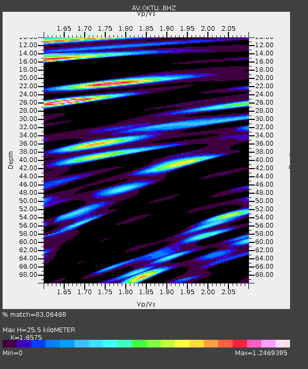
| Estimated Moho Depth: |
25.5 km |
| Estimated Crust Vp/Vs: |
1.66 |
| Assumed Crust Vp: |
5.88 km/s |
| Estimated Crust Vs: |
3.548 km/s |
| Estimated Crust Poisson's Ratio: |
0.21 |
|
| Radial Match: |
83.06469 % |
| Radial Bump: |
400 |
| Transverse Match: |
78.48148 % |
| Transverse Bump: |
400 |
| SOD ConfigId: |
27527651 |
| Insert Time: |
2022-06-10 02:43:48.969 +0000 |
| GWidth: |
2.5 |
| Max Bumps: |
400 |
| Tol: |
0.001 |
|

Signal To Noise
| Channel | StoN | STA | LTA |
| AV:OKTU: :BHZ:20220527T02:47:49.23899Z | 6.350606 | 5.553429E-7 | 8.744723E-8 |
| AV:OKTU: :BHN:20220527T02:47:49.23899Z | 1.2322272 | 2.7850322E-7 | 2.2601614E-7 |
| AV:OKTU: :BHE:20220527T02:47:49.23899Z | 2.0810874 | 2.8416662E-7 | 1.3654719E-7 |
| Arrivals |
| Ps | 2.9 SECOND |
| PpPs | 11 SECOND |
| PsPs/PpSs | 14 SECOND |


