You are here: Home > Network List > IU - Global Seismograph Network (GSN - IRIS/USGS) Stations List
> Station MAKZ Makanchi, Kazakhstan > Earthquake Result Viewer
MAKZ Makanchi, Kazakhstan - Earthquake Result Viewer

| Earthquake location: |
Timor Region |
| Earthquake latitude/longitude: |
-8.3/127.2 |
| Earthquake time(UTC): |
2022/05/27 (147) 02:36:05 GMT |
| Earthquake Depth: |
51 km |
| Earthquake Magnitude: |
6.1 Mww |
| Earthquake Catalog/Contributor: |
NEIC PDE/us |
|
| Network: |
IU Global Seismograph Network (GSN - IRIS/USGS) |
| Station: |
MAKZ Makanchi, Kazakhstan |
| Lat/Lon: |
46.81 N/81.98 E |
| Elevation: |
600 m |
|
| Distance: |
68.0 deg |
| Az: |
328.26 deg |
| Baz: |
130.711 deg |
| Ray Param: |
0.05649944 |
| Estimated Moho Depth: |
52.25 km |
| Estimated Crust Vp/Vs: |
1.74 |
| Assumed Crust Vp: |
6.571 km/s |
| Estimated Crust Vs: |
3.776 km/s |
| Estimated Crust Poisson's Ratio: |
0.25 |
|
| Radial Match: |
96.89613 % |
| Radial Bump: |
290 |
| Transverse Match: |
86.019394 % |
| Transverse Bump: |
400 |
| SOD ConfigId: |
27527651 |
| Insert Time: |
2022-06-10 02:45:37.234 +0000 |
| GWidth: |
2.5 |
| Max Bumps: |
400 |
| Tol: |
0.001 |
|
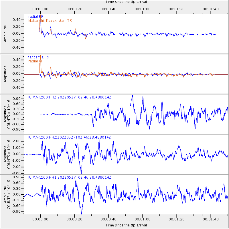
Signal To Noise
| Channel | StoN | STA | LTA |
| IU:MAKZ:00:HHZ:20220527T02:46:28.488014Z | 17.62914 | 9.4174175E-7 | 5.3419605E-8 |
| IU:MAKZ:00:HH1:20220527T02:46:28.488014Z | 8.201807 | 2.7418707E-7 | 3.3430084E-8 |
| IU:MAKZ:00:HH2:20220527T02:46:28.488014Z | 10.292078 | 2.868868E-7 | 2.7874528E-8 |
| Arrivals |
| Ps | 6.1 SECOND |
| PpPs | 21 SECOND |
| PsPs/PpSs | 27 SECOND |


