You are here: Home > Network List > NE - New England Seismic Network Stations List
> Station WES Weston, MA > Earthquake Result Viewer
WES Weston, MA - Earthquake Result Viewer
| Earthquake location: |
North Of Svalbard |
| Earthquake latitude/longitude: |
80.3/-1.9 |
| Earthquake time(UTC): |
2009/03/06 (065) 10:50:29 GMT |
| Earthquake Depth: |
9.0 km |
| Earthquake Magnitude: |
6.6 MB, 6.5 MS, 6.5 MW, 6.4 MW |
| Earthquake Catalog/Contributor: |
WHDF/NEIC |
|
| Network: |
NE New England Seismic Network |
| Station: |
WES Weston, MA |
| Lat/Lon: |
42.38 N/71.32 W |
| Elevation: |
60 m |
|
| Distance: |
45.1 deg |
| Az: |
258.396 deg |
| Baz: |
12.925 deg |
| Ray Param: |
0.07150606 |
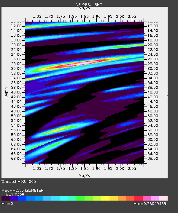
| Estimated Moho Depth: |
27.5 km |
| Estimated Crust Vp/Vs: |
1.84 |
| Assumed Crust Vp: |
6.419 km/s |
| Estimated Crust Vs: |
3.484 km/s |
| Estimated Crust Poisson's Ratio: |
0.29 |
|
| Radial Match: |
92.4065 % |
| Radial Bump: |
348 |
| Transverse Match: |
65.07756 % |
| Transverse Bump: |
400 |
| SOD ConfigId: |
2658 |
| Insert Time: |
2010-03-09 20:27:23.862 +0000 |
| GWidth: |
2.5 |
| Max Bumps: |
400 |
| Tol: |
0.001 |
|

Signal To Noise
| Channel | StoN | STA | LTA |
| NE:WES: :BHZ:20090306T10:58:14.890011Z | 11.169271 | 3.4384407E-6 | 3.0784827E-7 |
| NE:WES: :BHN:20090306T10:58:14.890011Z | 9.285608 | 1.7167195E-6 | 1.848796E-7 |
| NE:WES: :BHE:20090306T10:58:14.890011Z | 2.9465876 | 7.529509E-7 | 2.555332E-7 |
| Arrivals |
| Ps | 3.8 SECOND |
| PpPs | 11 SECOND |
| PsPs/PpSs | 15 SECOND |


