You are here: Home > Network List > NE - New England Seismic Network Stations List
> Station WES Weston, MA > Earthquake Result Viewer
WES Weston, MA - Earthquake Result Viewer
| Earthquake location: |
Kuril Islands |
| Earthquake latitude/longitude: |
46.0/151.4 |
| Earthquake time(UTC): |
2009/04/18 (108) 19:17:58 GMT |
| Earthquake Depth: |
35 km |
| Earthquake Magnitude: |
6.3 MB, 6.3 MS, 6.6 MW, 6.4 MW |
| Earthquake Catalog/Contributor: |
WHDF/NEIC |
|
| Network: |
NE New England Seismic Network |
| Station: |
WES Weston, MA |
| Lat/Lon: |
42.38 N/71.32 W |
| Elevation: |
60 m |
|
| Distance: |
84.1 deg |
| Az: |
30.369 deg |
| Baz: |
331.606 deg |
| Ray Param: |
0.04566353 |
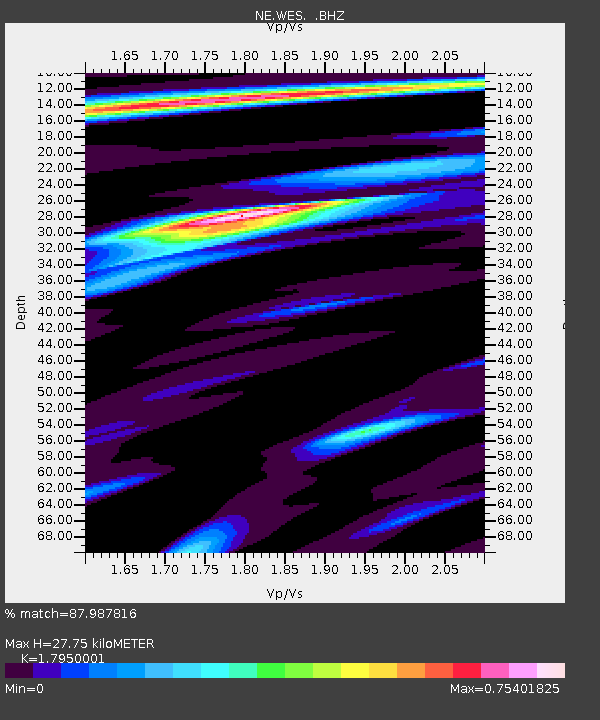
| Estimated Moho Depth: |
27.75 km |
| Estimated Crust Vp/Vs: |
1.80 |
| Assumed Crust Vp: |
6.419 km/s |
| Estimated Crust Vs: |
3.576 km/s |
| Estimated Crust Poisson's Ratio: |
0.27 |
|
| Radial Match: |
87.987816 % |
| Radial Bump: |
400 |
| Transverse Match: |
76.91938 % |
| Transverse Bump: |
400 |
| SOD ConfigId: |
2760 |
| Insert Time: |
2010-03-09 20:27:37.961 +0000 |
| GWidth: |
2.5 |
| Max Bumps: |
400 |
| Tol: |
0.001 |
|

Signal To Noise
| Channel | StoN | STA | LTA |
| NE:WES: :BHZ:20090418T19:29:55.091011Z | 11.249007 | 2.6265725E-6 | 2.3349372E-7 |
| NE:WES: :BHN:20090418T19:29:55.091011Z | 3.56735 | 5.8461796E-7 | 1.6388019E-7 |
| NE:WES: :BHE:20090418T19:29:55.091011Z | 1.7501671 | 2.940401E-7 | 1.6800686E-7 |
| Arrivals |
| Ps | 3.5 SECOND |
| PpPs | 12 SECOND |
| PsPs/PpSs | 15 SECOND |


