You are here: Home > Network List > IU - Global Seismograph Network (GSN - IRIS/USGS) Stations List
> Station PMG Port Moresby, New Guinea > Earthquake Result Viewer
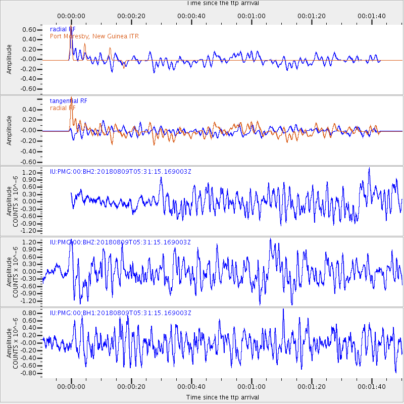
PMG Port Moresby, New Guinea - Earthquake Result Viewer
*The percent match for this event was below the threshold and hence no stack was calculated.
| Earthquake location: |
Sumbawa Region, Indonesia |
| Earthquake latitude/longitude: |
-8.4/116.2 |
| Earthquake time(UTC): |
2018/08/09 (221) 05:25:31 GMT |
| Earthquake Depth: |
10 km |
| Earthquake Magnitude: |
5.9 Mww |
| Earthquake Catalog/Contributor: |
NEIC PDE/us |
|
| Network: |
IU Global Seismograph Network (GSN - IRIS/USGS) |
| Station: |
PMG Port Moresby, New Guinea |
| Lat/Lon: |
9.40 S/147.16 E |
| Elevation: |
90 m |
|
| Distance: |
30.6 deg |
| Az: |
94.272 deg |
| Baz: |
269.398 deg |
| Ray Param: |
$rayparam |
*The percent match for this event was below the threshold and hence was not used in the summary stack. |
|
| Radial Match: |
71.36612 % |
| Radial Bump: |
400 |
| Transverse Match: |
58.369743 % |
| Transverse Bump: |
400 |
| SOD ConfigId: |
2778632 |
| Insert Time: |
2018-08-23 05:27:27.781 +0000 |
| GWidth: |
2.5 |
| Max Bumps: |
400 |
| Tol: |
0.001 |
|
Signal To Noise
| Channel | StoN | STA | LTA |
| IU:PMG:00:BHZ:20180809T05:31:15.169003Z | 5.6590977 | 7.855916E-7 | 1.3881925E-7 |
| IU:PMG:00:BH1:20180809T05:31:15.169003Z | 1.8145881 | 3.3246772E-7 | 1.8321938E-7 |
| IU:PMG:00:BH2:20180809T05:31:15.169003Z | 2.3665745 | 4.31737E-7 | 1.824312E-7 |
| Arrivals |
| Ps | |
| PpPs | |
| PsPs/PpSs | |


