You are here: Home > Network List > NE - New England Seismic Network Stations List
> Station WVL Waterville, ME > Earthquake Result Viewer
WVL Waterville, ME - Earthquake Result Viewer
| Earthquake location: |
Kuril Islands |
| Earthquake latitude/longitude: |
46.0/151.5 |
| Earthquake time(UTC): |
2009/04/07 (097) 04:23:33 GMT |
| Earthquake Depth: |
31 km |
| Earthquake Magnitude: |
6.5 MB, 6.8 MS, 6.9 MW, 6.9 MW |
| Earthquake Catalog/Contributor: |
WHDF/NEIC |
|
| Network: |
NE New England Seismic Network |
| Station: |
WVL Waterville, ME |
| Lat/Lon: |
44.56 N/69.66 W |
| Elevation: |
85 m |
|
| Distance: |
82.7 deg |
| Az: |
28.343 deg |
| Baz: |
332.448 deg |
| Ray Param: |
0.046674468 |
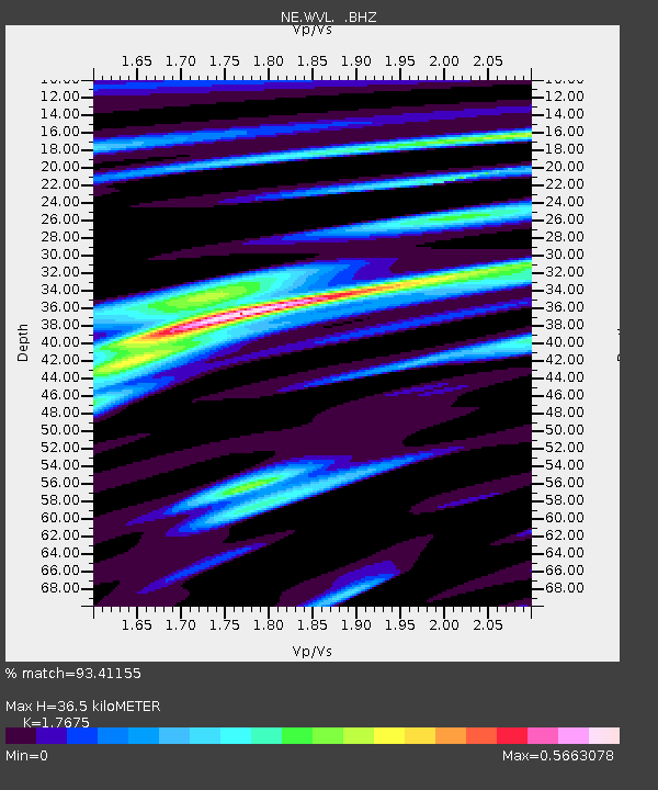
| Estimated Moho Depth: |
36.5 km |
| Estimated Crust Vp/Vs: |
1.77 |
| Assumed Crust Vp: |
6.419 km/s |
| Estimated Crust Vs: |
3.632 km/s |
| Estimated Crust Poisson's Ratio: |
0.26 |
|
| Radial Match: |
93.41155 % |
| Radial Bump: |
400 |
| Transverse Match: |
84.3428 % |
| Transverse Bump: |
400 |
| SOD ConfigId: |
2658 |
| Insert Time: |
2010-03-09 20:29:17.251 +0000 |
| GWidth: |
2.5 |
| Max Bumps: |
400 |
| Tol: |
0.001 |
|

Signal To Noise
| Channel | StoN | STA | LTA |
| NE:WVL: :BHZ:20090407T04:35:29.415015Z | 12.466395 | 4.5833376E-6 | 3.676554E-7 |
| NE:WVL: :BHN:20090407T04:35:29.415015Z | 7.794915 | 1.6881143E-6 | 2.1656608E-7 |
| NE:WVL: :BHE:20090407T04:35:29.415015Z | 1.790582 | 4.4109404E-7 | 2.4634116E-7 |
| Arrivals |
| Ps | 4.5 SECOND |
| PpPs | 15 SECOND |
| PsPs/PpSs | 20 SECOND |


