You are here: Home > Network List > NE - New England Seismic Network Stations List
> Station WVL Waterville, ME > Earthquake Result Viewer
WVL Waterville, ME - Earthquake Result Viewer
| Earthquake location: |
Dodecanese Islands, Greece |
| Earthquake latitude/longitude: |
35.8/27.9 |
| Earthquake time(UTC): |
2008/07/15 (197) 03:26:34 GMT |
| Earthquake Depth: |
52 km |
| Earthquake Magnitude: |
6.5 MB, 6.4 MW, 6.4 MW |
| Earthquake Catalog/Contributor: |
WHDF/NEIC |
|
| Network: |
NE New England Seismic Network |
| Station: |
WVL Waterville, ME |
| Lat/Lon: |
44.56 N/69.66 W |
| Elevation: |
85 m |
|
| Distance: |
70.7 deg |
| Az: |
311.317 deg |
| Baz: |
58.667 deg |
| Ray Param: |
0.05473366 |
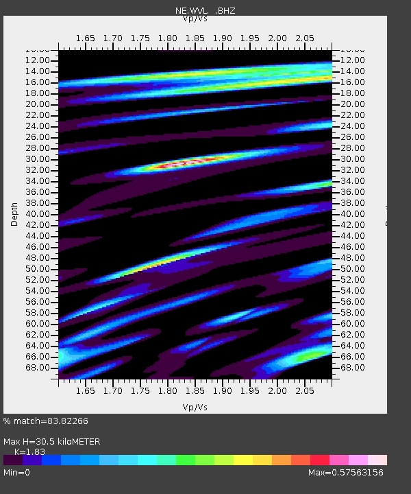
| Estimated Moho Depth: |
30.5 km |
| Estimated Crust Vp/Vs: |
1.83 |
| Assumed Crust Vp: |
6.419 km/s |
| Estimated Crust Vs: |
3.508 km/s |
| Estimated Crust Poisson's Ratio: |
0.29 |
|
| Radial Match: |
83.82266 % |
| Radial Bump: |
400 |
| Transverse Match: |
74.76431 % |
| Transverse Bump: |
400 |
| SOD ConfigId: |
2504 |
| Insert Time: |
2010-03-09 20:29:27.808 +0000 |
| GWidth: |
2.5 |
| Max Bumps: |
400 |
| Tol: |
0.001 |
|

Signal To Noise
| Channel | StoN | STA | LTA |
| NE:WVL: :BHZ:20080715T03:37:27.069019Z | 10.3022175 | 1.5886552E-6 | 1.5420517E-7 |
| NE:WVL: :BHN:20080715T03:37:27.069019Z | 3.044501 | 4.1941527E-7 | 1.3776157E-7 |
| NE:WVL: :BHE:20080715T03:37:27.069019Z | 6.2123785 | 5.8138744E-7 | 9.358532E-8 |
| Arrivals |
| Ps | 4.1 SECOND |
| PpPs | 13 SECOND |
| PsPs/PpSs | 17 SECOND |


