You are here: Home > Network List > NE - New England Seismic Network Stations List
> Station YLE New Haven, CT > Earthquake Result Viewer
YLE New Haven, CT - Earthquake Result Viewer
| Earthquake location: |
Kuril Islands |
| Earthquake latitude/longitude: |
46.0/151.5 |
| Earthquake time(UTC): |
2009/04/07 (097) 04:23:33 GMT |
| Earthquake Depth: |
31 km |
| Earthquake Magnitude: |
6.5 MB, 6.8 MS, 6.9 MW, 6.9 MW |
| Earthquake Catalog/Contributor: |
WHDF/NEIC |
|
| Network: |
NE New England Seismic Network |
| Station: |
YLE New Haven, CT |
| Lat/Lon: |
41.32 N/72.92 W |
| Elevation: |
10 m |
|
| Distance: |
84.4 deg |
| Az: |
32.02 deg |
| Baz: |
330.645 deg |
| Ray Param: |
0.045470927 |
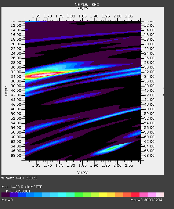
| Estimated Moho Depth: |
33.0 km |
| Estimated Crust Vp/Vs: |
1.69 |
| Assumed Crust Vp: |
6.472 km/s |
| Estimated Crust Vs: |
3.841 km/s |
| Estimated Crust Poisson's Ratio: |
0.23 |
|
| Radial Match: |
84.23823 % |
| Radial Bump: |
400 |
| Transverse Match: |
64.20687 % |
| Transverse Bump: |
400 |
| SOD ConfigId: |
2658 |
| Insert Time: |
2010-03-09 20:30:24.640 +0000 |
| GWidth: |
2.5 |
| Max Bumps: |
400 |
| Tol: |
0.001 |
|

Signal To Noise
| Channel | StoN | STA | LTA |
| NE:YLE: :BHZ:20090407T04:35:31.215002Z | 6.5569944 | 3.924295E-6 | 5.984899E-7 |
| NE:YLE: :BHN:20090407T04:35:31.215002Z | 2.6585283 | 1.0325078E-6 | 3.8837572E-7 |
| NE:YLE: :BHE:20090407T04:35:31.215002Z | 1.3314377 | 6.945616E-7 | 5.216629E-7 |
| Arrivals |
| Ps | 3.6 SECOND |
| PpPs | 13 SECOND |
| PsPs/PpSs | 17 SECOND |


