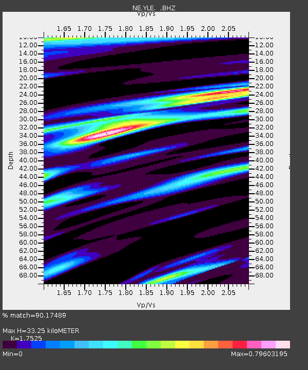
YLE New Haven, CT - Earthquake Result Viewer

Earthquake location: Near Coast Of Chiapas, Mexico
Earthquake latitude/longitude: 14.4/-92.4
Earthquake time(UTC): 2008/10/16 (290) 19:41:25 GMT
Earthquake Depth: 24 km
Earthquake Magnitude: 6.1 MB, 6.6 MS, 6.7 MW, 6.6 MW
Earthquake Catalog/Contributor: WHDF/NEIC
Network: NE New England Seismic Network
Station: YLE New Haven, CT
Lat/Lon: 41.32 N/72.92 W
Elevation: 10 m
Distance: 31.7 deg
Az: 28.519 deg
Baz: 217.888 deg
Ray Param: 0.07894542
Estimated Moho Depth: 33.25 km
Estimated Crust Vp/Vs: 1.75
Assumed Crust Vp: 6.472 km/s
Estimated Crust Vs: 3.693 km/s
Estimated Crust Poisson's Ratio: 0.26
Radial Match: 90.17489 %
Radial Bump: 260
Transverse Match: 60.010033 %
Transverse Bump: 400
SOD ConfigId: 2556
Insert Time: 2010-03-09 20:30:25.982 +0000
GWidth: 2.5
Max Bumps: 400
Tol: 0.001

Signal To Noise

ChannelStoNSTALTA
NE:YLE: :BHZ:20081016T19:47:16.665007Z3.90518641.8246586E-64.6723983E-7
NE:YLE: :BHN:20081016T19:47:16.665007Z2.8739689.1922107E-73.1984388E-7
NE:YLE: :BHE:20081016T19:47:16.665007Z2.6292968.3076526E-73.1596488E-7
Arrivals
Ps4.2 SECOND
PpPs13 SECOND
PsPs/PpSs17 SECOND