You are here: Home > Network List > XM99 - Rio Grande Seismic Transect Stations List
> Station NM18 NewMexico18 > Earthquake Result Viewer
NM18 NewMexico18 - Earthquake Result Viewer
| Earthquake location: |
Fiji Islands Region |
| Earthquake latitude/longitude: |
-16.2/-177.7 |
| Earthquake time(UTC): |
2000/07/09 (191) 14:42:27 GMT |
| Earthquake Depth: |
33 km |
| Earthquake Magnitude: |
5.0 MB, 5.5 MS |
| Earthquake Catalog/Contributor: |
WHDF/NEIC |
|
| Network: |
XM Rio Grande Seismic Transect |
| Station: |
NM18 NewMexico18 |
| Lat/Lon: |
33.40 N/105.34 W |
| Elevation: |
1624 m |
|
| Distance: |
84.7 deg |
| Az: |
53.175 deg |
| Baz: |
246.833 deg |
| Ray Param: |
0.045226894 |
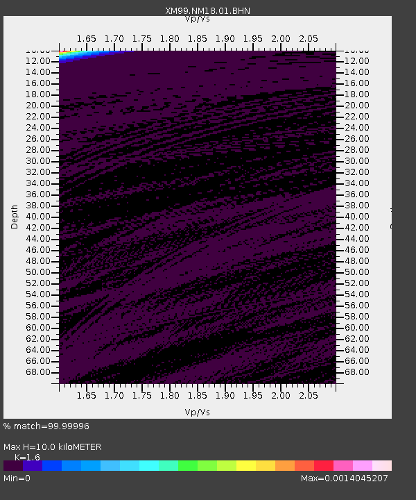
| Estimated Moho Depth: |
10.0 km |
| Estimated Crust Vp/Vs: |
1.60 |
| Assumed Crust Vp: |
6.232 km/s |
| Estimated Crust Vs: |
3.895 km/s |
| Estimated Crust Poisson's Ratio: |
0.18 |
|
| Radial Match: |
99.99996 % |
| Radial Bump: |
2 |
| Transverse Match: |
99.99979 % |
| Transverse Bump: |
2 |
| SOD ConfigId: |
16820 |
| Insert Time: |
2010-02-26 17:26:50.121 +0000 |
| GWidth: |
2.5 |
| Max Bumps: |
400 |
| Tol: |
0.001 |
|
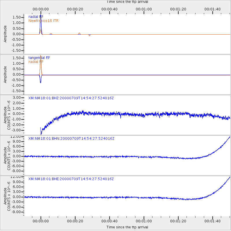
Signal To Noise
| Channel | StoN | STA | LTA |
| XM:NM18:01:BHN:20000709T14:54:27.524016Z | 0.8754273 | 9.122662E-7 | 1.0420811E-6 |
| XM:NM18:01:BHE:20000709T14:54:27.524016Z | 0.8666021 | 9.042249E-7 | 1.0434142E-6 |
| XM:NM18:01:BHZ:20000709T14:54:27.524016Z | 0.84844327 | 9.139228E-7 | 1.0771761E-6 |
| Arrivals |
| Ps | 1.0 SECOND |
| PpPs | 4.1 SECOND |
| PsPs/PpSs | 5.1 SECOND |


