You are here: Home > Network List > TA - USArray Transportable Network (new EarthScope stations) Stations List
> Station POKR Poker Plat Research Range, AK, USA > Earthquake Result Viewer
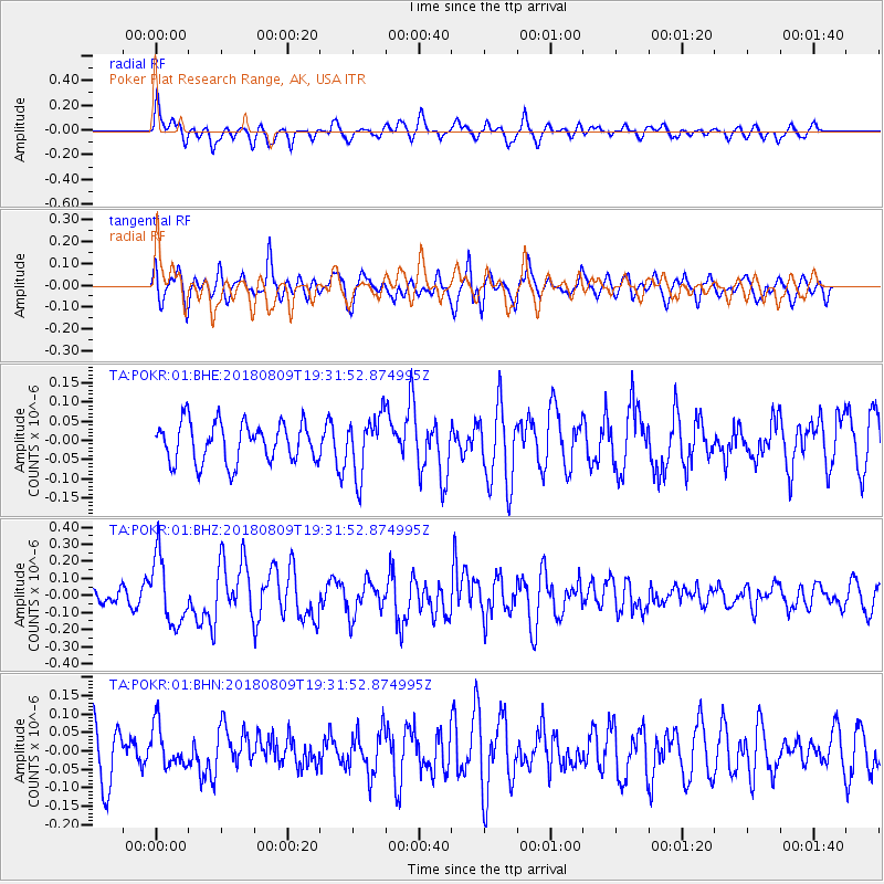
POKR Poker Plat Research Range, AK, USA - Earthquake Result Viewer
*The percent match for this event was below the threshold and hence no stack was calculated.
| Earthquake location: |
Near Coast Of Guatemala |
| Earthquake latitude/longitude: |
13.6/-91.2 |
| Earthquake time(UTC): |
2018/08/09 (221) 19:21:53 GMT |
| Earthquake Depth: |
29 km |
| Earthquake Magnitude: |
5.6 Mww |
| Earthquake Catalog/Contributor: |
NEIC PDE/us |
|
| Network: |
TA USArray Transportable Network (new EarthScope stations) |
| Station: |
POKR Poker Plat Research Range, AK, USA |
| Lat/Lon: |
65.12 N/147.43 W |
| Elevation: |
501 m |
|
| Distance: |
63.9 deg |
| Az: |
336.938 deg |
| Baz: |
115.797 deg |
| Ray Param: |
$rayparam |
*The percent match for this event was below the threshold and hence was not used in the summary stack. |
|
| Radial Match: |
56.545307 % |
| Radial Bump: |
400 |
| Transverse Match: |
59.72391 % |
| Transverse Bump: |
398 |
| SOD ConfigId: |
2778632 |
| Insert Time: |
2018-08-23 19:24:53.746 +0000 |
| GWidth: |
2.5 |
| Max Bumps: |
400 |
| Tol: |
0.001 |
|
Signal To Noise
| Channel | StoN | STA | LTA |
| TA:POKR:01:BHZ:20180809T19:31:52.874995Z | 4.0681386 | 1.9177222E-7 | 4.714004E-8 |
| TA:POKR:01:BHN:20180809T19:31:52.874995Z | 0.93312466 | 5.681521E-8 | 6.0887054E-8 |
| TA:POKR:01:BHE:20180809T19:31:52.874995Z | 1.4676986 | 7.5618225E-8 | 5.152163E-8 |
| Arrivals |
| Ps | |
| PpPs | |
| PsPs/PpSs | |


