You are here: Home > Network List > US - United States National Seismic Network Stations List
> Station HAWA Hanford, Washington, USA > Earthquake Result Viewer
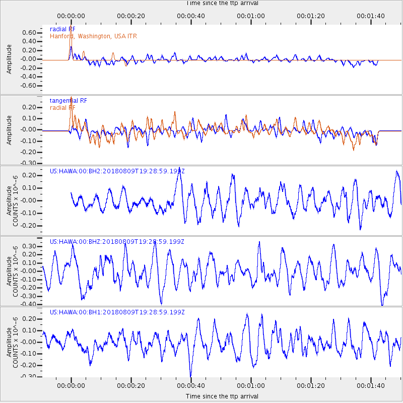
HAWA Hanford, Washington, USA - Earthquake Result Viewer
*The percent match for this event was below the threshold and hence no stack was calculated.
| Earthquake location: |
Near Coast Of Guatemala |
| Earthquake latitude/longitude: |
13.6/-91.2 |
| Earthquake time(UTC): |
2018/08/09 (221) 19:21:53 GMT |
| Earthquake Depth: |
29 km |
| Earthquake Magnitude: |
5.6 Mww |
| Earthquake Catalog/Contributor: |
NEIC PDE/us |
|
| Network: |
US United States National Seismic Network |
| Station: |
HAWA Hanford, Washington, USA |
| Lat/Lon: |
46.39 N/119.53 W |
| Elevation: |
364 m |
|
| Distance: |
40.5 deg |
| Az: |
329.583 deg |
| Baz: |
134.656 deg |
| Ray Param: |
$rayparam |
*The percent match for this event was below the threshold and hence was not used in the summary stack. |
|
| Radial Match: |
52.886623 % |
| Radial Bump: |
400 |
| Transverse Match: |
44.39708 % |
| Transverse Bump: |
400 |
| SOD ConfigId: |
2778632 |
| Insert Time: |
2018-08-23 19:25:19.052 +0000 |
| GWidth: |
2.5 |
| Max Bumps: |
400 |
| Tol: |
0.001 |
|
Signal To Noise
| Channel | StoN | STA | LTA |
| US:HAWA:00:BHZ:20180809T19:28:59.199Z | 2.2677374 | 2.1612772E-7 | 9.530544E-8 |
| US:HAWA:00:BH1:20180809T19:28:59.199Z | 1.4566007 | 6.147463E-8 | 4.2204174E-8 |
| US:HAWA:00:BH2:20180809T19:28:59.199Z | 1.0880182 | 5.3593638E-8 | 4.9258034E-8 |
| Arrivals |
| Ps | |
| PpPs | |
| PsPs/PpSs | |


