You are here: Home > Network List > XM99 - Rio Grande Seismic Transect Stations List
> Station NM18 NewMexico18 > Earthquake Result Viewer
NM18 NewMexico18 - Earthquake Result Viewer
| Earthquake location: |
Kermadec Islands Region |
| Earthquake latitude/longitude: |
-31.5/179.7 |
| Earthquake time(UTC): |
2000/08/15 (228) 04:30:08 GMT |
| Earthquake Depth: |
358 km |
| Earthquake Magnitude: |
6.0 MB, 6.6 MW, 6.6 MW |
| Earthquake Catalog/Contributor: |
WHDF/NEIC |
|
| Network: |
XM Rio Grande Seismic Transect |
| Station: |
NM18 NewMexico18 |
| Lat/Lon: |
33.40 N/105.34 W |
| Elevation: |
1624 m |
|
| Distance: |
95.7 deg |
| Az: |
54.269 deg |
| Baz: |
235.979 deg |
| Ray Param: |
0.04038668 |
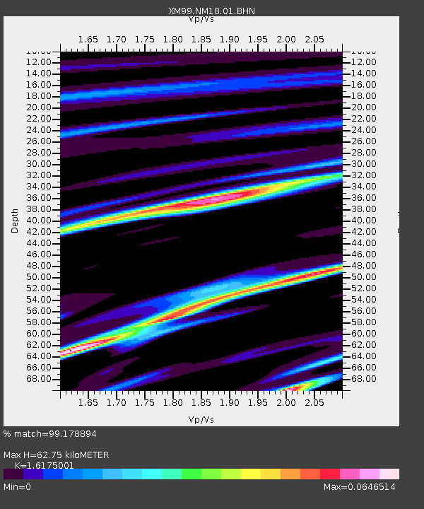
| Estimated Moho Depth: |
62.75 km |
| Estimated Crust Vp/Vs: |
1.62 |
| Assumed Crust Vp: |
6.232 km/s |
| Estimated Crust Vs: |
3.853 km/s |
| Estimated Crust Poisson's Ratio: |
0.19 |
|
| Radial Match: |
99.178894 % |
| Radial Bump: |
80 |
| Transverse Match: |
80.56652 % |
| Transverse Bump: |
359 |
| SOD ConfigId: |
3744 |
| Insert Time: |
2010-02-26 17:26:53.982 +0000 |
| GWidth: |
2.5 |
| Max Bumps: |
400 |
| Tol: |
0.001 |
|
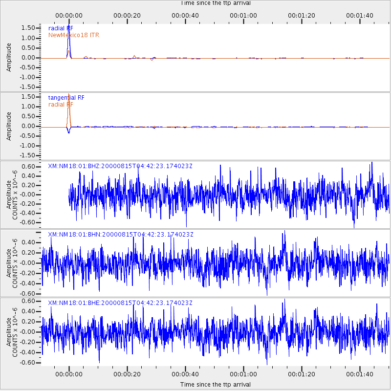
Signal To Noise
| Channel | StoN | STA | LTA |
| XM:NM18:01:BHN:20000815T04:42:23.174023Z | 0.9089025 | 1.6141583E-7 | 1.775942E-7 |
| XM:NM18:01:BHE:20000815T04:42:23.174023Z | 0.9394564 | 1.6302714E-7 | 1.7353348E-7 |
| XM:NM18:01:BHZ:20000815T04:42:23.174023Z | 0.9257779 | 1.8310273E-7 | 1.9778257E-7 |
| Arrivals |
| Ps | 6.3 SECOND |
| PpPs | 26 SECOND |
| PsPs/PpSs | 32 SECOND |


