You are here: Home > Network List > US - United States National Seismic Network Stations List
> Station HLID Hailey, Idaho, USA > Earthquake Result Viewer
HLID Hailey, Idaho, USA - Earthquake Result Viewer
*The percent match for this event was below the threshold and hence no stack was calculated.
| Earthquake location: |
Near Coast Of Guatemala |
| Earthquake latitude/longitude: |
13.6/-91.2 |
| Earthquake time(UTC): |
2018/08/09 (221) 19:21:53 GMT |
| Earthquake Depth: |
29 km |
| Earthquake Magnitude: |
5.6 Mww |
| Earthquake Catalog/Contributor: |
NEIC PDE/us |
|
| Network: |
US United States National Seismic Network |
| Station: |
HLID Hailey, Idaho, USA |
| Lat/Lon: |
43.56 N/114.41 W |
| Elevation: |
1772 m |
|
| Distance: |
35.9 deg |
| Az: |
330.75 deg |
| Baz: |
139.182 deg |
| Ray Param: |
$rayparam |
*The percent match for this event was below the threshold and hence was not used in the summary stack. |
|
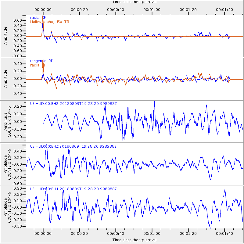
| Radial Match: |
75.962715 % |
| Radial Bump: |
354 |
| Transverse Match: |
54.10206 % |
| Transverse Bump: |
400 |
| SOD ConfigId: |
2778632 |
| Insert Time: |
2018-08-23 19:25:20.200 +0000 |
| GWidth: |
2.5 |
| Max Bumps: |
400 |
| Tol: |
0.001 |
|
Signal To Noise
| Channel | StoN | STA | LTA |
| US:HLID:00:BHZ:20180809T19:28:20.998988Z | 2.9836667 | 2.7955647E-7 | 9.369562E-8 |
| US:HLID:00:BH1:20180809T19:28:20.998988Z | 2.2100463 | 1.7296732E-7 | 7.826412E-8 |
| US:HLID:00:BH2:20180809T19:28:20.998988Z | 1.8655424 | 1.1834006E-7 | 6.343467E-8 |
| Arrivals |
| Ps | |
| PpPs | |
| PsPs/PpSs | |


