You are here: Home > Network List > XM99 - Rio Grande Seismic Transect Stations List
> Station NM18 NewMexico18 > Earthquake Result Viewer
NM18 NewMexico18 - Earthquake Result Viewer
| Earthquake location: |
Bonin Islands, Japan Region |
| Earthquake latitude/longitude: |
28.9/139.6 |
| Earthquake time(UTC): |
2000/08/06 (219) 07:27:12 GMT |
| Earthquake Depth: |
395 km |
| Earthquake Magnitude: |
6.3 MB, 7.3 MW, 7.3 MW |
| Earthquake Catalog/Contributor: |
WHDF/NEIC |
|
| Network: |
XM Rio Grande Seismic Transect |
| Station: |
NM18 NewMexico18 |
| Lat/Lon: |
33.40 N/105.34 W |
| Elevation: |
1624 m |
|
| Distance: |
92.8 deg |
| Az: |
49.322 deg |
| Baz: |
307.319 deg |
| Ray Param: |
0.041121107 |
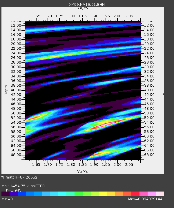
| Estimated Moho Depth: |
54.75 km |
| Estimated Crust Vp/Vs: |
1.95 |
| Assumed Crust Vp: |
6.232 km/s |
| Estimated Crust Vs: |
3.204 km/s |
| Estimated Crust Poisson's Ratio: |
0.32 |
|
| Radial Match: |
87.20552 % |
| Radial Bump: |
298 |
| Transverse Match: |
99.584236 % |
| Transverse Bump: |
55 |
| SOD ConfigId: |
3744 |
| Insert Time: |
2010-02-26 17:26:56.545 +0000 |
| GWidth: |
2.5 |
| Max Bumps: |
400 |
| Tol: |
0.001 |
|
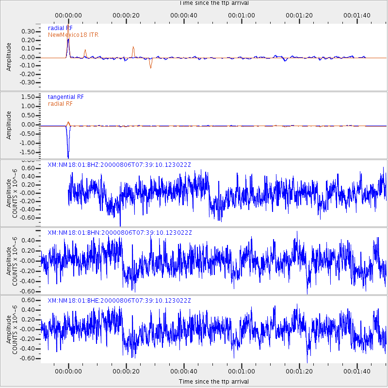
Signal To Noise
| Channel | StoN | STA | LTA |
| XM:NM18:01:BHN:20000806T07:39:10.123022Z | 0.77979183 | 1.602597E-7 | 2.0551602E-7 |
| XM:NM18:01:BHE:20000806T07:39:10.123022Z | 0.8111284 | 1.6175017E-7 | 1.9941376E-7 |
| XM:NM18:01:BHZ:20000806T07:39:10.123022Z | 0.82155675 | 1.8202041E-7 | 2.215555E-7 |
| Arrivals |
| Ps | 8.4 SECOND |
| PpPs | 25 SECOND |
| PsPs/PpSs | 34 SECOND |


