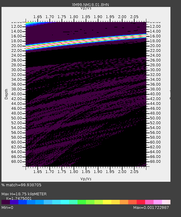
NM18 NewMexico18 - Earthquake Result Viewer
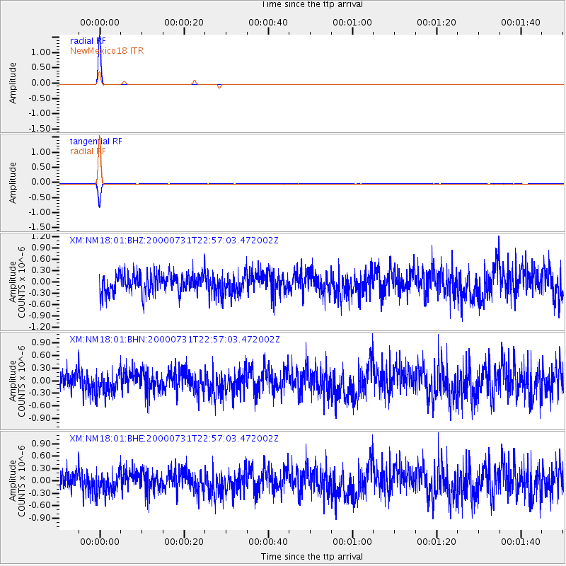
Earthquake location: Fiji Islands Region
Earthquake latitude/longitude: -16.7/174.5
Earthquake time(UTC): 2000/07/31 (213) 22:44:30 GMT
Earthquake Depth: 10 km
Earthquake Magnitude: 5.7 MB, 5.6 MS, 6.1 MW, 6.1 MW
Earthquake Catalog/Contributor: WHDF/NEIC
Network: XM Rio Grande Seismic Transect
Station: NM18 NewMexico18
Lat/Lon: 33.40 N/105.34 W
Elevation: 1624 m
Distance: 91.1 deg
Az: 55.512 deg
Baz: 250.789 deg
Ray Param: 0.041627515
Estimated Moho Depth: 18.75 km
Estimated Crust Vp/Vs: 1.75
Assumed Crust Vp: 6.232 km/s
Estimated Crust Vs: 3.566 km/s
Estimated Crust Poisson's Ratio: 0.26
Radial Match: 99.938705 %
Radial Bump: 7
Transverse Match: 99.31455 %
Transverse Bump: 61
SOD ConfigId: 3744
Insert Time: 2010-02-26 17:26:58.101 +0000
GWidth: 2.5
Max Bumps: 400
Tol: 0.001

Signal To Noise

ChannelStoNSTALTA
XM:NM18:01:BHN:20000731T22:57:03.472002Z1.10528922.616494E-72.3672482E-7
XM:NM18:01:BHE:20000731T22:57:03.472002Z1.10887932.5658085E-72.3138755E-7
XM:NM18:01:BHZ:20000731T22:57:03.472002Z1.10514642.8744276E-72.6009474E-7
Arrivals
Ps2.3 SECOND
PpPs8.1 SECOND
PsPs/PpSs10 SECOND