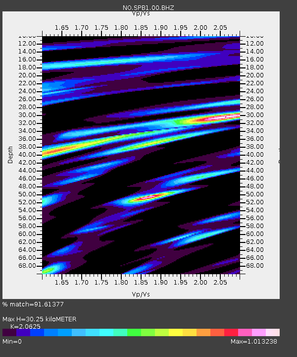
SPB1 SPITSBERGEN ARRAY SITE B1, SVALBARD - Earthquake Result Viewer
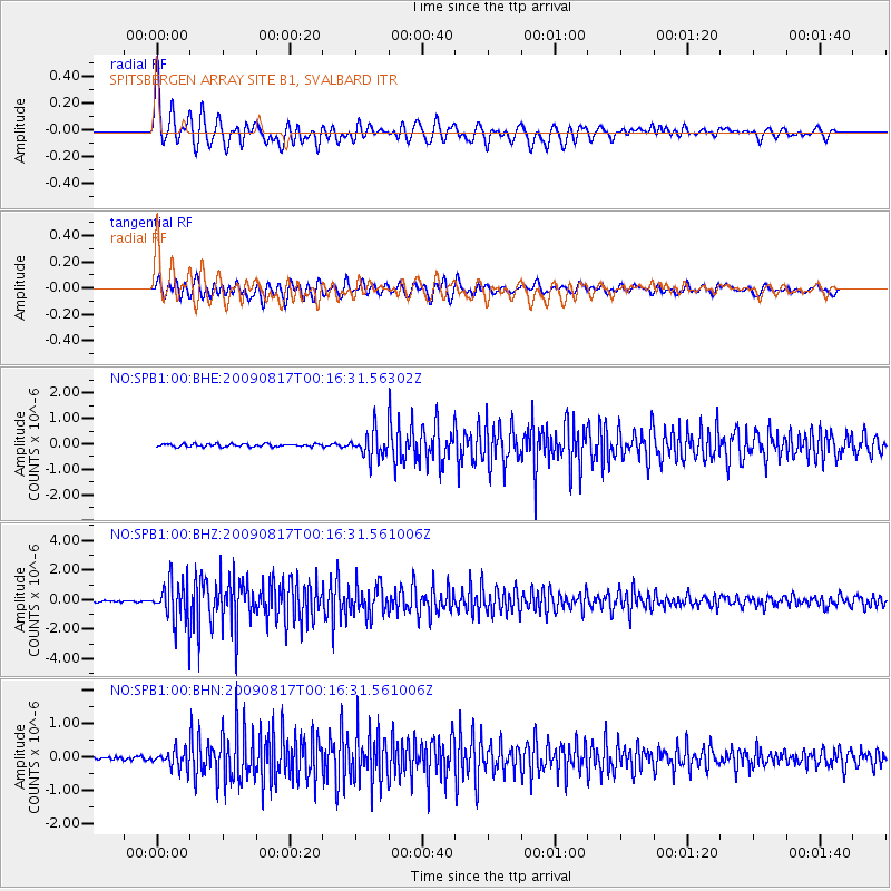
Earthquake location: Southwestern Ryukyu Isl., Japan
Earthquake latitude/longitude: 23.5/123.5
Earthquake time(UTC): 2009/08/17 (229) 00:05:49 GMT
Earthquake Depth: 20 km
Earthquake Magnitude: 6.2 MB, 6.6 MS, 6.7 MW, 6.6 MW
Earthquake Catalog/Contributor: WHDF/NEIC
Network: NO Norwegian Seismic Array Network
Station: SPB1 SPITSBERGEN ARRAY SITE B1, SVALBARD
Lat/Lon: 78.18 N/16.39 E
Elevation: 301 m
Distance: 70.6 deg
Az: 347.941 deg
Baz: 68.478 deg
Ray Param: 0.054861832
Estimated Moho Depth: 30.25 km
Estimated Crust Vp/Vs: 2.06
Assumed Crust Vp: 6.545 km/s
Estimated Crust Vs: 3.173 km/s
Estimated Crust Poisson's Ratio: 0.35
Radial Match: 91.61377 %
Radial Bump: 400
Transverse Match: 85.39517 %
Transverse Bump: 400
SOD ConfigId: 2622
Insert Time: 2010-03-09 20:33:24.583 +0000
GWidth: 2.5
Max Bumps: 400
Tol: 0.001

Signal To Noise

ChannelStoNSTALTA
NO:SPB1:00:BHZ:20090817T00:16:31.561006Z24.5885491.4490807E-65.8933157E-8
NO:SPB1:00:BHN:20090817T00:16:31.561006Z5.96521762.5657388E-74.3011653E-8
NO:SPB1:00:BHE:20090817T00:16:31.56302Z8.8215854.9976165E-75.665214E-8
Arrivals
Ps5.1 SECOND
PpPs14 SECOND
PsPs/PpSs19 SECOND