You are here: Home > Network List > AK - Alaska Regional Network Stations List
> Station M16K Timber Creek, AK, USA > Earthquake Result Viewer
M16K Timber Creek, AK, USA - Earthquake Result Viewer
| Earthquake location: |
Tonga Islands |
| Earthquake latitude/longitude: |
-20.1/-173.1 |
| Earthquake time(UTC): |
2022/05/28 (148) 15:32:25 GMT |
| Earthquake Depth: |
10 km |
| Earthquake Magnitude: |
5.7 mb |
| Earthquake Catalog/Contributor: |
NEIC PDE/us |
|
| Network: |
AK Alaska Regional Network |
| Station: |
M16K Timber Creek, AK, USA |
| Lat/Lon: |
61.02 N/158.96 W |
| Elevation: |
394 m |
|
| Distance: |
81.6 deg |
| Az: |
6.921 deg |
| Baz: |
193.452 deg |
| Ray Param: |
0.0474799 |
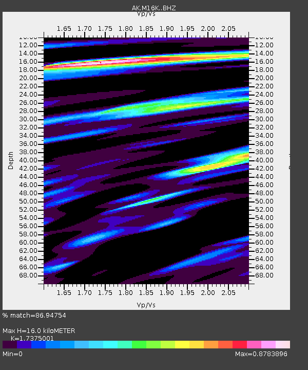
| Estimated Moho Depth: |
16.0 km |
| Estimated Crust Vp/Vs: |
1.74 |
| Assumed Crust Vp: |
6.276 km/s |
| Estimated Crust Vs: |
3.612 km/s |
| Estimated Crust Poisson's Ratio: |
0.25 |
|
| Radial Match: |
86.94754 % |
| Radial Bump: |
395 |
| Transverse Match: |
71.42292 % |
| Transverse Bump: |
400 |
| SOD ConfigId: |
27527651 |
| Insert Time: |
2022-06-11 15:35:16.542 +0000 |
| GWidth: |
2.5 |
| Max Bumps: |
400 |
| Tol: |
0.001 |
|

Signal To Noise
| Channel | StoN | STA | LTA |
| AK:M16K: :BHZ:20220528T15:44:11.980015Z | 2.9443755 | 1.9242388E-7 | 6.5353035E-8 |
| AK:M16K: :BHN:20220528T15:44:11.980015Z | 1.729062 | 9.131041E-8 | 5.280922E-8 |
| AK:M16K: :BHE:20220528T15:44:11.980015Z | 0.88413775 | 6.262214E-8 | 7.082849E-8 |
| Arrivals |
| Ps | 1.9 SECOND |
| PpPs | 6.8 SECOND |
| PsPs/PpSs | 8.7 SECOND |


