You are here: Home > Network List > XM99 - Rio Grande Seismic Transect Stations List
> Station NM18 NewMexico18 > Earthquake Result Viewer
NM18 NewMexico18 - Earthquake Result Viewer

| Earthquake location: |
Hokkaido, Japan Region |
| Earthquake latitude/longitude: |
43.1/145.9 |
| Earthquake time(UTC): |
2001/04/26 (116) 17:48:57 GMT |
| Earthquake Depth: |
86 km |
| Earthquake Magnitude: |
5.7 MB, 6.0 MW, 6.0 MW |
| Earthquake Catalog/Contributor: |
WHDF/NEIC |
|
| Network: |
XM Rio Grande Seismic Transect |
| Station: |
NM18 NewMexico18 |
| Lat/Lon: |
33.40 N/105.34 W |
| Elevation: |
1624 m |
|
| Distance: |
79.9 deg |
| Az: |
53.589 deg |
| Baz: |
315.195 deg |
| Ray Param: |
0.04849357 |
| Estimated Moho Depth: |
10.0 km |
| Estimated Crust Vp/Vs: |
1.60 |
| Assumed Crust Vp: |
6.232 km/s |
| Estimated Crust Vs: |
3.895 km/s |
| Estimated Crust Poisson's Ratio: |
0.18 |
|
| Radial Match: |
99.995285 % |
| Radial Bump: |
2 |
| Transverse Match: |
99.9519 % |
| Transverse Bump: |
7 |
| SOD ConfigId: |
16820 |
| Insert Time: |
2010-02-26 17:27:04.893 +0000 |
| GWidth: |
2.5 |
| Max Bumps: |
400 |
| Tol: |
0.001 |
|
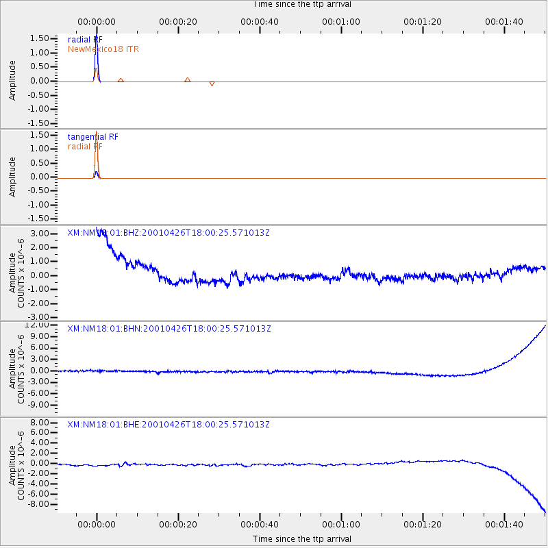
Signal To Noise
| Channel | StoN | STA | LTA |
| XM:NM18:01:BHN:20010426T18:00:25.571013Z | 0.90522945 | 9.211405E-7 | 1.0175768E-6 |
| XM:NM18:01:BHE:20010426T18:00:25.571013Z | 0.99794275 | 7.01212E-7 | 7.0265753E-7 |
| XM:NM18:01:BHZ:20010426T18:00:25.571013Z | 0.96242166 | 1.054695E-6 | 1.0958761E-6 |
| Arrivals |
| Ps | 1.0 SECOND |
| PpPs | 4.1 SECOND |
| PsPs/PpSs | 5.0 SECOND |


