You are here: Home > Network List > AG - Arkansas Seismic Network Stations List
> Station WHAR Woolly Hollow State Park,AR > Earthquake Result Viewer
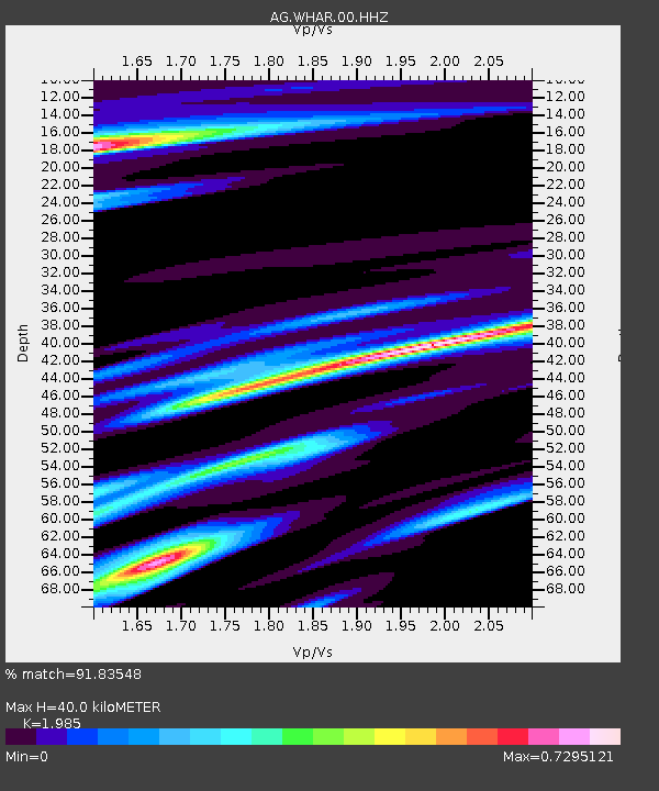
WHAR Woolly Hollow State Park,AR - Earthquake Result Viewer
| Earthquake location: |
Kuril Islands |
| Earthquake latitude/longitude: |
48.5/154.8 |
| Earthquake time(UTC): |
2018/08/10 (222) 18:12:05 GMT |
| Earthquake Depth: |
16 km |
| Earthquake Magnitude: |
5.9 Mww |
| Earthquake Catalog/Contributor: |
NEIC PDE/us |
|
| Network: |
AG Arkansas Seismic Network |
| Station: |
WHAR Woolly Hollow State Park,AR |
| Lat/Lon: |
35.29 N/92.29 W |
| Elevation: |
184 m |
|
| Distance: |
77.5 deg |
| Az: |
50.514 deg |
| Baz: |
321.108 deg |
| Ray Param: |
0.050295632 |
| Estimated Moho Depth: |
40.0 km |
| Estimated Crust Vp/Vs: |
1.99 |
| Assumed Crust Vp: |
6.498 km/s |
| Estimated Crust Vs: |
3.273 km/s |
| Estimated Crust Poisson's Ratio: |
0.33 |
|
| Radial Match: |
91.83548 % |
| Radial Bump: |
400 |
| Transverse Match: |
77.57862 % |
| Transverse Bump: |
396 |
| SOD ConfigId: |
2778632 |
| Insert Time: |
2018-08-24 18:12:37.689 +0000 |
| GWidth: |
2.5 |
| Max Bumps: |
400 |
| Tol: |
0.001 |
|

Signal To Noise
| Channel | StoN | STA | LTA |
| AG:WHAR:00:HHZ:20180810T18:23:28.595029Z | 14.083791 | 1.5313019E-6 | 1.0872797E-7 |
| AG:WHAR:00:HHN:20180810T18:23:28.595029Z | 4.0618505 | 3.0051024E-7 | 7.398357E-8 |
| AG:WHAR:00:HHE:20180810T18:23:28.595029Z | 2.645051 | 1.9969933E-7 | 7.549924E-8 |
| Arrivals |
| Ps | 6.2 SECOND |
| PpPs | 18 SECOND |
| PsPs/PpSs | 24 SECOND |


