You are here: Home > Network List > AK - Alaska Regional Network Stations List
> Station H21K Melozitna River, AK, USA > Earthquake Result Viewer
H21K Melozitna River, AK, USA - Earthquake Result Viewer
| Earthquake location: |
Sichuan, China |
| Earthquake latitude/longitude: |
30.4/103.0 |
| Earthquake time(UTC): |
2022/06/01 (152) 09:00:08 GMT |
| Earthquake Depth: |
12 km |
| Earthquake Magnitude: |
5.8 mww |
| Earthquake Catalog/Contributor: |
NEIC PDE/us |
|
| Network: |
AK Alaska Regional Network |
| Station: |
H21K Melozitna River, AK, USA |
| Lat/Lon: |
65.66 N/152.80 W |
| Elevation: |
520 m |
|
| Distance: |
68.3 deg |
| Az: |
25.625 deg |
| Baz: |
295.644 deg |
| Ray Param: |
0.05640514 |
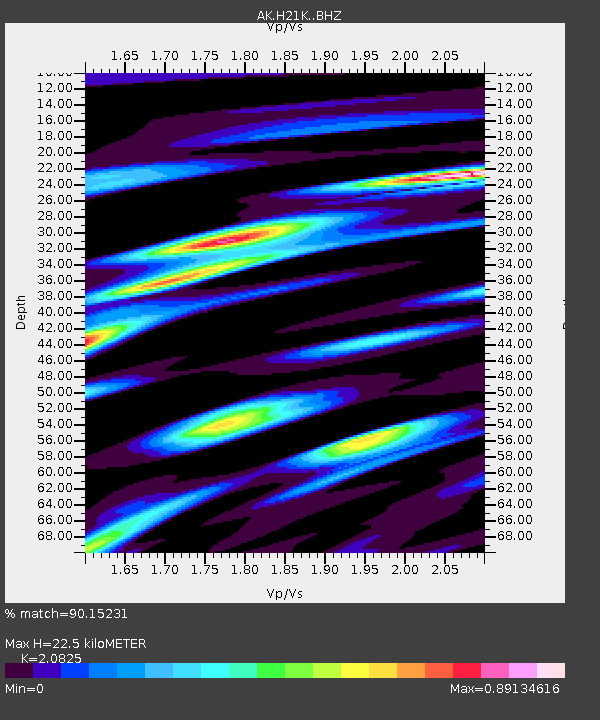
| Estimated Moho Depth: |
22.5 km |
| Estimated Crust Vp/Vs: |
2.08 |
| Assumed Crust Vp: |
6.566 km/s |
| Estimated Crust Vs: |
3.153 km/s |
| Estimated Crust Poisson's Ratio: |
0.35 |
|
| Radial Match: |
90.15231 % |
| Radial Bump: |
305 |
| Transverse Match: |
74.0358 % |
| Transverse Bump: |
400 |
| SOD ConfigId: |
28208852 |
| Insert Time: |
2022-06-27 14:03:08.519 +0000 |
| GWidth: |
2.5 |
| Max Bumps: |
400 |
| Tol: |
0.001 |
|

Signal To Noise
| Channel | StoN | STA | LTA |
| AK:H21K: :BHZ:20220601T09:10:37.880004Z | 12.036449 | 1.1015117E-6 | 9.151467E-8 |
| AK:H21K: :BHN:20220601T09:10:37.880004Z | 3.6528714 | 2.8514577E-7 | 7.806072E-8 |
| AK:H21K: :BHE:20220601T09:10:37.880004Z | 4.300483 | 4.082907E-7 | 9.494065E-8 |
| Arrivals |
| Ps | 3.8 SECOND |
| PpPs | 10 SECOND |
| PsPs/PpSs | 14 SECOND |


