You are here: Home > Network List > XM99 - Rio Grande Seismic Transect Stations List
> Station NM18 NewMexico18 > Earthquake Result Viewer
NM18 NewMexico18 - Earthquake Result Viewer
| Earthquake location: |
Southern Bolivia |
| Earthquake latitude/longitude: |
-20.9/-67.3 |
| Earthquake time(UTC): |
1999/09/15 (258) 03:01:24 GMT |
| Earthquake Depth: |
218 km |
| Earthquake Magnitude: |
6.0 MB, 6.4 MW, 6.4 MW |
| Earthquake Catalog/Contributor: |
WHDF/NEIC |
|
| Network: |
XM Rio Grande Seismic Transect |
| Station: |
NM18 NewMexico18 |
| Lat/Lon: |
33.40 N/105.34 W |
| Elevation: |
1624 m |
|
| Distance: |
65.1 deg |
| Az: |
325.346 deg |
| Baz: |
140.549 deg |
| Ray Param: |
0.057833273 |
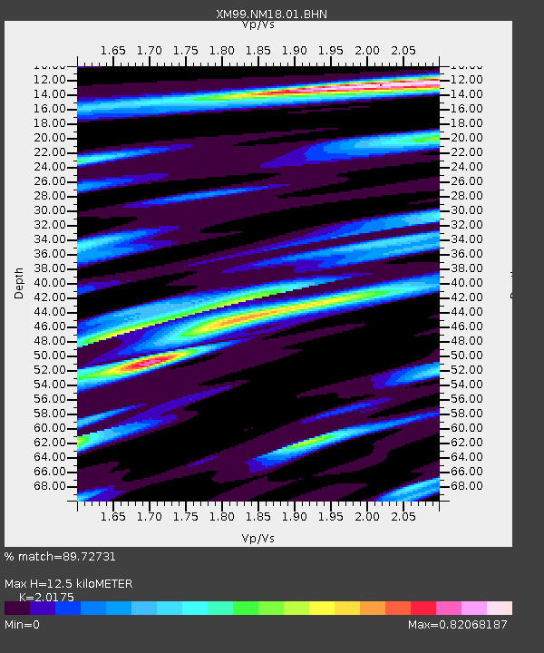
| Estimated Moho Depth: |
12.5 km |
| Estimated Crust Vp/Vs: |
2.02 |
| Assumed Crust Vp: |
6.232 km/s |
| Estimated Crust Vs: |
3.089 km/s |
| Estimated Crust Poisson's Ratio: |
0.34 |
|
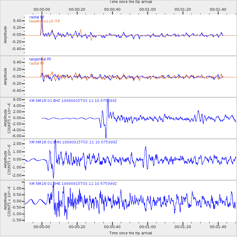
| Radial Match: |
89.72731 % |
| Radial Bump: |
334 |
| Transverse Match: |
82.723434 % |
| Transverse Bump: |
400 |
| SOD ConfigId: |
27569 |
| Insert Time: |
2010-02-26 17:27:11.593 +0000 |
| GWidth: |
2.5 |
| Max Bumps: |
400 |
| Tol: |
0.001 |
|
Signal To Noise
| Channel | StoN | STA | LTA |
| XM:NM18:01:BHN:19990915T03:11:10.675999Z | 3.4542828 | 5.479403E-7 | 1.5862636E-7 |
| XM:NM18:01:BHE:19990915T03:11:10.675999Z | 2.6870682 | 2.4296583E-7 | 9.042042E-8 |
| XM:NM18:01:BHZ:19990915T03:11:10.675999Z | 8.557207 | 1.1814633E-6 | 1.3806647E-7 |
| Arrivals |
| Ps | 2.1 SECOND |
| PpPs | 5.9 SECOND |
| PsPs/PpSs | 8.0 SECOND |


