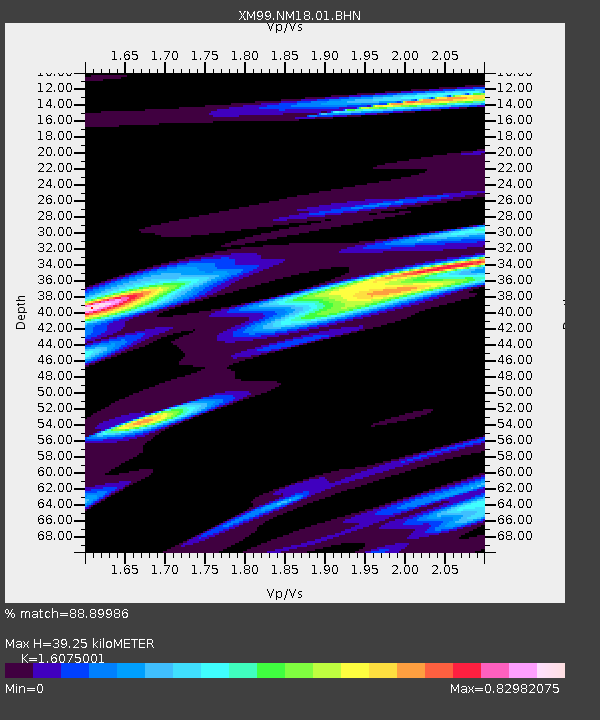
NM18 NewMexico18 - Earthquake Result Viewer
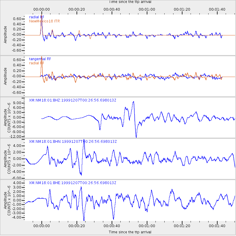
Earthquake location: Kodiak Island Region, Alaska
Earthquake latitude/longitude: 57.4/-154.5
Earthquake time(UTC): 1999/12/07 (341) 00:19:49 GMT
Earthquake Depth: 41 km
Earthquake Magnitude: 6.5 MB, 6.1 MS, 6.4 MW, 6.3 ML
Earthquake Catalog/Contributor: WHDF/NEIC
Network: XM Rio Grande Seismic Transect
Station: NM18 NewMexico18
Lat/Lon: 33.40 N/105.34 W
Elevation: 1624 m
Distance: 40.8 deg
Az: 104.415 deg
Baz: 321.14 deg
Ray Param: 0.07408497
Estimated Moho Depth: 39.25 km
Estimated Crust Vp/Vs: 1.61
Assumed Crust Vp: 6.232 km/s
Estimated Crust Vs: 3.877 km/s
Estimated Crust Poisson's Ratio: 0.18
Radial Match: 88.89986 %
Radial Bump: 400
Transverse Match: 77.0287 %
Transverse Bump: 400
SOD ConfigId: 27569
Insert Time: 2010-02-26 17:27:13.750 +0000
GWidth: 2.5
Max Bumps: 400
Tol: 0.001

Signal To Noise

ChannelStoNSTALTA
XM:NM18:01:BHN:19991207T00:26:56.698013Z1.90253931.7398656E-69.144966E-7
XM:NM18:01:BHE:19991207T00:26:56.698013Z2.03289411.0440651E-65.135856E-7
XM:NM18:01:BHZ:19991207T00:26:56.698013Z4.7350892.9207201E-66.168248E-7
Arrivals
Ps4.1 SECOND
PpPs15 SECOND
PsPs/PpSs19 SECOND