You are here: Home > Network List > XM99 - Rio Grande Seismic Transect Stations List
> Station NM18 NewMexico18 > Earthquake Result Viewer
NM18 NewMexico18 - Earthquake Result Viewer
| Earthquake location: |
Tonga Islands |
| Earthquake latitude/longitude: |
-15.9/-174.0 |
| Earthquake time(UTC): |
1999/12/07 (341) 21:29:49 GMT |
| Earthquake Depth: |
138 km |
| Earthquake Magnitude: |
6.2 MB, 6.4 MW, 6.4 MW |
| Earthquake Catalog/Contributor: |
WHDF/NEIC |
|
| Network: |
XM Rio Grande Seismic Transect |
| Station: |
NM18 NewMexico18 |
| Lat/Lon: |
33.40 N/105.34 W |
| Elevation: |
1624 m |
|
| Distance: |
81.7 deg |
| Az: |
51.93 deg |
| Baz: |
244.893 deg |
| Ray Param: |
0.0470596 |
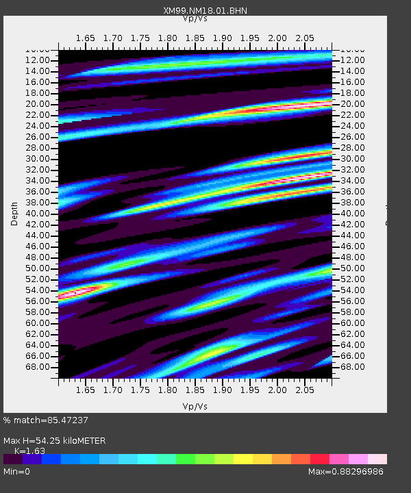
| Estimated Moho Depth: |
54.25 km |
| Estimated Crust Vp/Vs: |
1.63 |
| Assumed Crust Vp: |
6.232 km/s |
| Estimated Crust Vs: |
3.823 km/s |
| Estimated Crust Poisson's Ratio: |
0.20 |
|
| Radial Match: |
85.47237 % |
| Radial Bump: |
400 |
| Transverse Match: |
60.98897 % |
| Transverse Bump: |
400 |
| SOD ConfigId: |
27569 |
| Insert Time: |
2010-02-26 17:27:14.841 +0000 |
| GWidth: |
2.5 |
| Max Bumps: |
400 |
| Tol: |
0.001 |
|
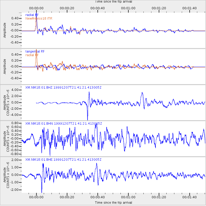
Signal To Noise
| Channel | StoN | STA | LTA |
| XM:NM18:01:BHN:19991207T21:41:21.413005Z | 1.5695804 | 2.951828E-7 | 1.8806477E-7 |
| XM:NM18:01:BHE:19991207T21:41:21.413005Z | 5.643605 | 7.450753E-7 | 1.3202114E-7 |
| XM:NM18:01:BHZ:19991207T21:41:21.413005Z | 10.501164 | 1.6439261E-6 | 1.5654703E-7 |
| Arrivals |
| Ps | 5.6 SECOND |
| PpPs | 22 SECOND |
| PsPs/PpSs | 28 SECOND |


