You are here: Home > Network List > IU - Global Seismograph Network (GSN - IRIS/USGS) Stations List
> Station SFJD Sondre Stromfjord, Greenland > Earthquake Result Viewer
SFJD Sondre Stromfjord, Greenland - Earthquake Result Viewer

| Earthquake location: |
Kuril Islands |
| Earthquake latitude/longitude: |
48.5/154.8 |
| Earthquake time(UTC): |
2018/08/10 (222) 18:12:05 GMT |
| Earthquake Depth: |
16 km |
| Earthquake Magnitude: |
5.9 Mww |
| Earthquake Catalog/Contributor: |
NEIC PDE/us |
|
| Network: |
IU Global Seismograph Network (GSN - IRIS/USGS) |
| Station: |
SFJD Sondre Stromfjord, Greenland |
| Lat/Lon: |
67.00 N/50.62 W |
| Elevation: |
330 m |
|
| Distance: |
63.3 deg |
| Az: |
10.879 deg |
| Baz: |
341.362 deg |
| Ray Param: |
0.059683904 |
| Estimated Moho Depth: |
16.75 km |
| Estimated Crust Vp/Vs: |
2.09 |
| Assumed Crust Vp: |
6.459 km/s |
| Estimated Crust Vs: |
3.091 km/s |
| Estimated Crust Poisson's Ratio: |
0.35 |
|
| Radial Match: |
91.42226 % |
| Radial Bump: |
400 |
| Transverse Match: |
84.497444 % |
| Transverse Bump: |
400 |
| SOD ConfigId: |
2778632 |
| Insert Time: |
2018-08-24 18:16:52.216 +0000 |
| GWidth: |
2.5 |
| Max Bumps: |
400 |
| Tol: |
0.001 |
|
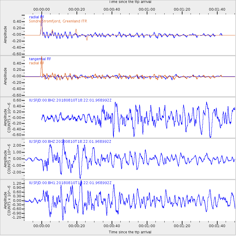
Signal To Noise
| Channel | StoN | STA | LTA |
| IU:SFJD:00:BHZ:20180810T18:22:01.968992Z | 10.693518 | 9.655653E-7 | 9.029444E-8 |
| IU:SFJD:00:BH1:20180810T18:22:01.968992Z | 6.759182 | 4.613497E-7 | 6.825526E-8 |
| IU:SFJD:00:BH2:20180810T18:22:01.968992Z | 2.3261883 | 1.5665023E-7 | 6.734202E-8 |
| Arrivals |
| Ps | 2.9 SECOND |
| PpPs | 7.7 SECOND |
| PsPs/PpSs | 11 SECOND |


