You are here: Home > Network List > IW - Intermountain West Stations List
> Station IMW Indian Meadow, Wyoming, USA > Earthquake Result Viewer
IMW Indian Meadow, Wyoming, USA - Earthquake Result Viewer
| Earthquake location: |
Kuril Islands |
| Earthquake latitude/longitude: |
48.5/154.8 |
| Earthquake time(UTC): |
2018/08/10 (222) 18:12:05 GMT |
| Earthquake Depth: |
16 km |
| Earthquake Magnitude: |
5.9 Mww |
| Earthquake Catalog/Contributor: |
NEIC PDE/us |
|
| Network: |
IW Intermountain West |
| Station: |
IMW Indian Meadow, Wyoming, USA |
| Lat/Lon: |
43.90 N/110.94 W |
| Elevation: |
2646 m |
|
| Distance: |
61.3 deg |
| Az: |
55.246 deg |
| Baz: |
310.855 deg |
| Ray Param: |
0.0609287 |
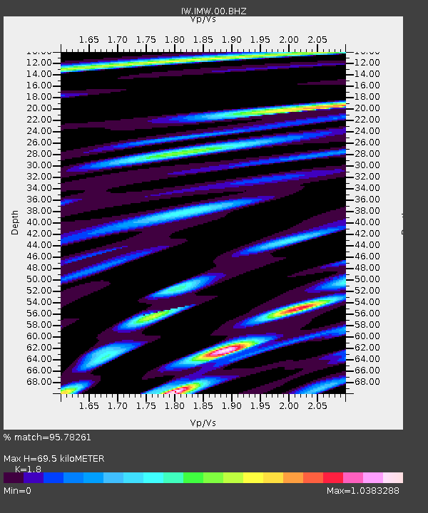
| Estimated Moho Depth: |
69.5 km |
| Estimated Crust Vp/Vs: |
1.80 |
| Assumed Crust Vp: |
6.207 km/s |
| Estimated Crust Vs: |
3.448 km/s |
| Estimated Crust Poisson's Ratio: |
0.28 |
|
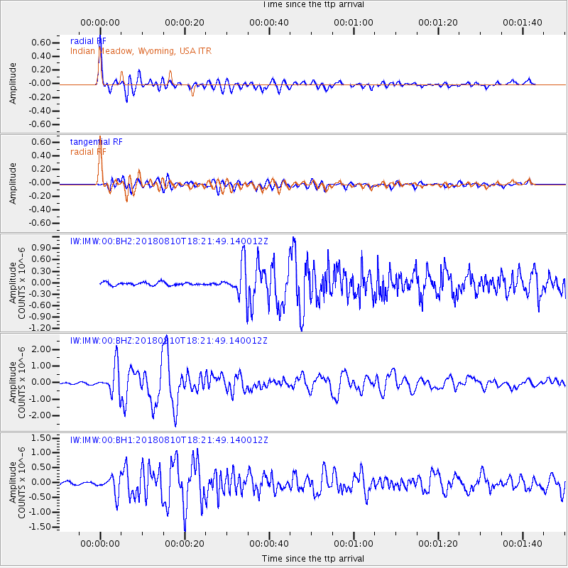
| Radial Match: |
95.78261 % |
| Radial Bump: |
400 |
| Transverse Match: |
85.54306 % |
| Transverse Bump: |
400 |
| SOD ConfigId: |
2778632 |
| Insert Time: |
2018-08-24 18:17:15.477 +0000 |
| GWidth: |
2.5 |
| Max Bumps: |
400 |
| Tol: |
0.001 |
|
Signal To Noise
| Channel | StoN | STA | LTA |
| IW:IMW:00:BHZ:20180810T18:21:49.140012Z | 19.855467 | 8.7132224E-7 | 4.388324E-8 |
| IW:IMW:00:BH1:20180810T18:21:49.140012Z | 6.3862495 | 3.063292E-7 | 4.7966996E-8 |
| IW:IMW:00:BH2:20180810T18:21:49.140012Z | 11.316419 | 4.3082454E-7 | 3.807075E-8 |
| Arrivals |
| Ps | 9.3 SECOND |
| PpPs | 30 SECOND |
| PsPs/PpSs | 39 SECOND |


