You are here: Home > Network List > NM - Cooperative New Madrid Seismic Network Stations List
> Station LNXT Lenox,TN > Earthquake Result Viewer
LNXT Lenox,TN - Earthquake Result Viewer
| Earthquake location: |
Kuril Islands |
| Earthquake latitude/longitude: |
48.5/154.8 |
| Earthquake time(UTC): |
2018/08/10 (222) 18:12:05 GMT |
| Earthquake Depth: |
16 km |
| Earthquake Magnitude: |
5.9 Mww |
| Earthquake Catalog/Contributor: |
NEIC PDE/us |
|
| Network: |
NM Cooperative New Madrid Seismic Network |
| Station: |
LNXT Lenox,TN |
| Lat/Lon: |
36.10 N/89.49 W |
| Elevation: |
144 m |
|
| Distance: |
78.2 deg |
| Az: |
48.173 deg |
| Baz: |
322.241 deg |
| Ray Param: |
0.049766 |
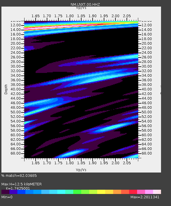
| Estimated Moho Depth: |
12.5 km |
| Estimated Crust Vp/Vs: |
1.74 |
| Assumed Crust Vp: |
6.444 km/s |
| Estimated Crust Vs: |
3.698 km/s |
| Estimated Crust Poisson's Ratio: |
0.25 |
|
| Radial Match: |
82.03685 % |
| Radial Bump: |
334 |
| Transverse Match: |
61.73883 % |
| Transverse Bump: |
377 |
| SOD ConfigId: |
2778632 |
| Insert Time: |
2018-08-24 18:18:28.809 +0000 |
| GWidth: |
2.5 |
| Max Bumps: |
400 |
| Tol: |
0.001 |
|

Signal To Noise
| Channel | StoN | STA | LTA |
| NM:LNXT:00:HHZ:20180810T18:23:32.905027Z | 5.623753 | 2.377649E-6 | 4.2278685E-7 |
| NM:LNXT:00:HHN:20180810T18:23:32.905027Z | 1.103416 | 9.670455E-7 | 8.7641064E-7 |
| NM:LNXT:00:HHE:20180810T18:23:32.905027Z | 3.3252957 | 2.834886E-6 | 8.525214E-7 |
| Arrivals |
| Ps | 1.5 SECOND |
| PpPs | 5.2 SECOND |
| PsPs/PpSs | 6.6 SECOND |


