You are here: Home > Network List > NM - Cooperative New Madrid Seismic Network Stations List
> Station PENM Penman,Portageville,MO > Earthquake Result Viewer
PENM Penman,Portageville,MO - Earthquake Result Viewer
| Earthquake location: |
Kuril Islands |
| Earthquake latitude/longitude: |
48.5/154.8 |
| Earthquake time(UTC): |
2018/08/10 (222) 18:12:05 GMT |
| Earthquake Depth: |
16 km |
| Earthquake Magnitude: |
5.9 Mww |
| Earthquake Catalog/Contributor: |
NEIC PDE/us |
|
| Network: |
NM Cooperative New Madrid Seismic Network |
| Station: |
PENM Penman,Portageville,MO |
| Lat/Lon: |
36.45 N/89.63 W |
| Elevation: |
85 m |
|
| Distance: |
77.9 deg |
| Az: |
48.045 deg |
| Baz: |
322.133 deg |
| Ray Param: |
0.049999602 |
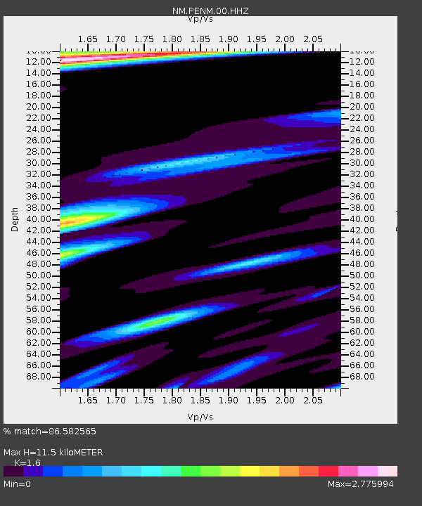
| Estimated Moho Depth: |
11.5 km |
| Estimated Crust Vp/Vs: |
1.60 |
| Assumed Crust Vp: |
6.444 km/s |
| Estimated Crust Vs: |
4.027 km/s |
| Estimated Crust Poisson's Ratio: |
0.18 |
|
| Radial Match: |
86.582565 % |
| Radial Bump: |
339 |
| Transverse Match: |
68.10105 % |
| Transverse Bump: |
400 |
| SOD ConfigId: |
2778632 |
| Insert Time: |
2018-08-24 18:18:35.890 +0000 |
| GWidth: |
2.5 |
| Max Bumps: |
400 |
| Tol: |
0.001 |
|

Signal To Noise
| Channel | StoN | STA | LTA |
| NM:PENM:00:HHZ:20180810T18:23:31.015012Z | 4.681223 | 1.547188E-6 | 3.3050938E-7 |
| NM:PENM:00:HHN:20180810T18:23:31.015012Z | 1.6513321 | 8.0691E-7 | 4.886419E-7 |
| NM:PENM:00:HHE:20180810T18:23:31.015012Z | 1.5151167 | 8.569281E-7 | 5.6558554E-7 |
| Arrivals |
| Ps | 1.1 SECOND |
| PpPs | 4.5 SECOND |
| PsPs/PpSs | 5.6 SECOND |


